Snake Ridge Fire Quick Facts
Acres: 42
Cause: Lightning
Containment: 0% Start Date: July 28, 2023
Location: 11 miles southwest of Show Low.
Fuels: Grass, brush
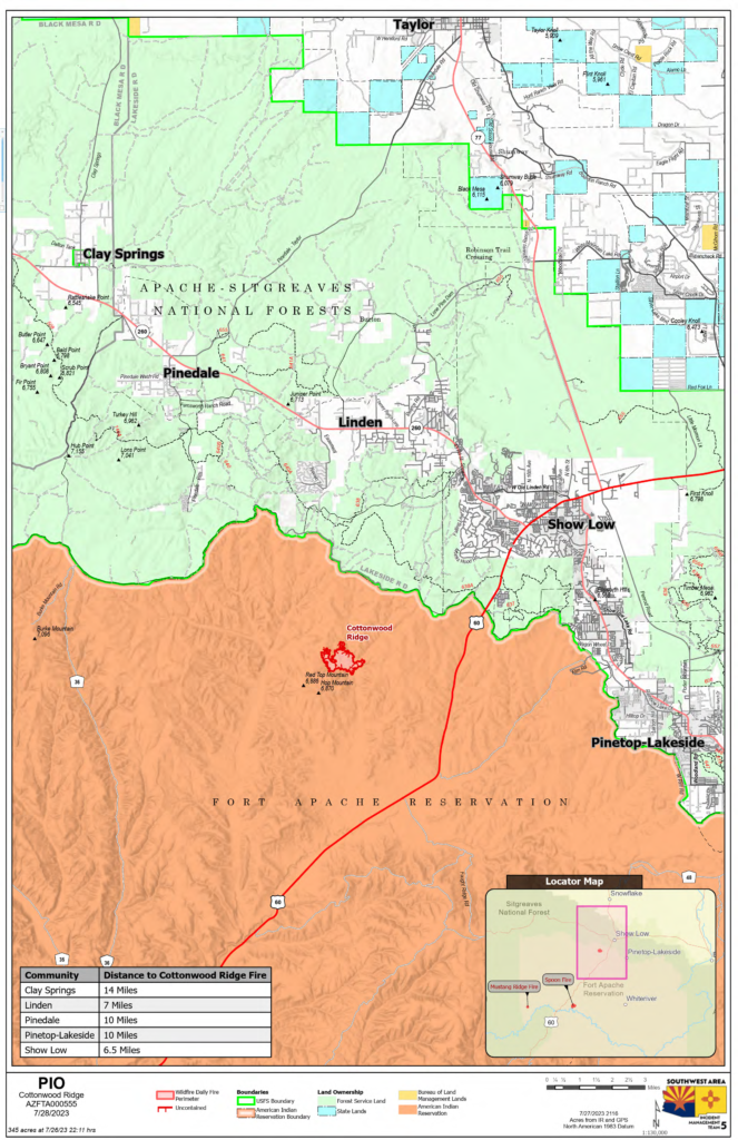
Cottonwood Ridge Fire Quick Facts
Acres: 345
Cause: Lightning
Containment: 30% Start Date: July 23, 2023
Location: 4 miles south of Show Low, AZ
Fuels: Timber, grass, brush
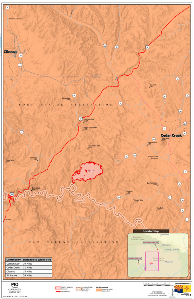
Spoon Fire Quick Facts
Acres: 4,531
Cause: Lightning
Containment: 0% Start Date: July 24, 2023
Location: 2.5 miles east of Highway 60 between Globe and Show Low, 11 miles southwest of Cedar Creek
Fuels: Piñyon- Juniper, Manzanita, Grass, Cedar
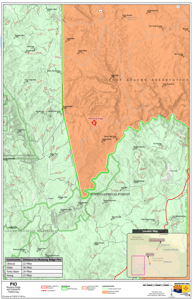
Mustang Ridge Fire Quick Facts
Acres: 103
Cause: Lightning
Containment: 75% Start Date: July 25, 2023
Location: 12 miles west of Highway 60 between Globe and Show Low, AZ
Fuels: Piñon- Juniper, Manzanita, Grass, Cedar
Total personnel for all incidents: 250
Crews continue to build and reinforce fireline and utilize aircraft to wet down hot spots on the Cottonwood Ridge, Spoon, Cottonwood Ridge and Snake Ridge fires.
Snake Ridge Fire: Friday afternoon an isolated thunderstorm passed over the Cottonwood Ridge area and a lightning strike started a new fire, named the Snake Ridge Fire. As of Friday evening, the fire is estimated at approximately 15 acres, and several air tankers and helicopters flew water and fire retardant to slow the spread. Crew will follow the air resources and begin to construct fireline to contain this new start. Light winds helped prevent significant fire growth.
Spoon Fire Update: The fire was active on Friday, pushed toward the Salt River by outflow winds from thunderstorms that passed through the area. Crews worked to keep the fire from moving west toward Highway 60, supported by air tankers and helicopters. Fire managers are looking for roads and natural barriers to keep the fire from moving to the north and east, while starting to build fireline to the west side of the fire to protect Highway 60.
Cottonwood Ridge Fire Update: The Cottonwood Ridge Fire stayed within the established firelines. Minimal smoke remains and firefighters were able to reinforce firelines, gaining 30% containment on the eastern edge of the fire. Saturday, firefighters will continue to construct and improve firelines working their way around the northern side of the fire, unless isolated thunderstorm activity forces firefighters to move away from the fire edge until the storm passes. Work to secure the south/southwest side of the fire will also continue.
Mustang Ridge Fire Update: The Mustang Fire has not grown for several days, and firefighters are feeling more confident that the fire will remain within the current boundary. There was minimal fire activity, and the fire will continue to be monitored for any fire activity.
Weather: Temperatures on Saturday will remain in the 90s on the Cottonwood Ridge Fire and could reach 100 near the Spoon Fire. Thunderstorms, which brings gusty winds, remain in the forecast, along with a chance of afternoon/evening rain.
Evacuations: None.
Residents and visitors should take time to become familiar with the Ready, Set, Go evacuation model. These steps help you to be READY in the event of an emergency by preparing now. Additionally, sign up for the Navajo County Alert System at https://tinyurl.com/y4vwrasw.
Smoke: Highway 60 will be impacted by smoke as the Spoon Fire continues to progress. Larger columns of smoke are more likely in the afternoon/evening. Please use caution when traveling along smokey roadways. For information on smoke and air quality visit https://www.airnow.gov.
Closures: Highway 60 remains open. The southwest portion of Fort Apache is closed, including all Salt River sites within the closure area.
Fire Restrictions: There are several fire restrictions in place depending on location.
• Fort Apache Agency: Stage 2 Fire Restrictions
o No campfire, fireworks, outdoor smoking, debris burning or discharging of firearms. Power saws cannot be used between 10 am and 8 pm. All motorized travel is restricted to developed roads.
• Show Low, Navajo County and Apache Sitgreaves National Forest: Stage 1 Fire Restrictions
o No campfires (except in developed recreation sites), no smoking outdoors, no welding, no fireworks.
More Information:
Inciweb:
• Cottonwood Ridge: https://inciweb.nwcg.gov/incident-information/azfta-cottonwood-ridge-fire
• Spoon: https://inciweb.nwcg.gov/incident-information/azfta-spoon-fire
Facebook: https://www.facebook.com/BIAFAAFireMgt/
![]()
![]()
![]()