
Daily Update July 28, 2023
Southwest Area Incident Management Team 5 Assumes Command of Three Fires on Fort Apache Cottonwood Ridge, Mustang, Spoon Fire
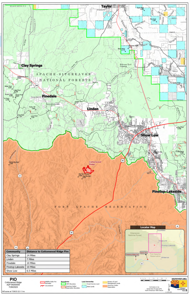
Cottonwood Ridge Fire
Quick Facts*Acres: 345
Cause: Lightning Containment: 0%
Start Date: July 23, 2023
Location: 4 miles south of Show Low, AZ
Fuels: Timber, grass, brush
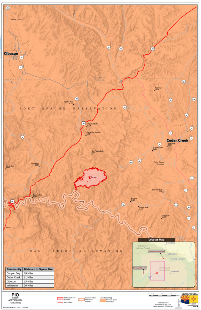
Spoon Fire Quick Facts
*Acres: 3,202
Cause: Lightning
Containment: 0%
Start Date: July 24, 2023
Location: 2.5 miles east of Highway 60 between Globe and Show Low, AZ. 20 miles south of Cibicue, +30 miles south of Show Low
Fuels: Piñyon- Juniper, Manzanita, Grass, Cedar
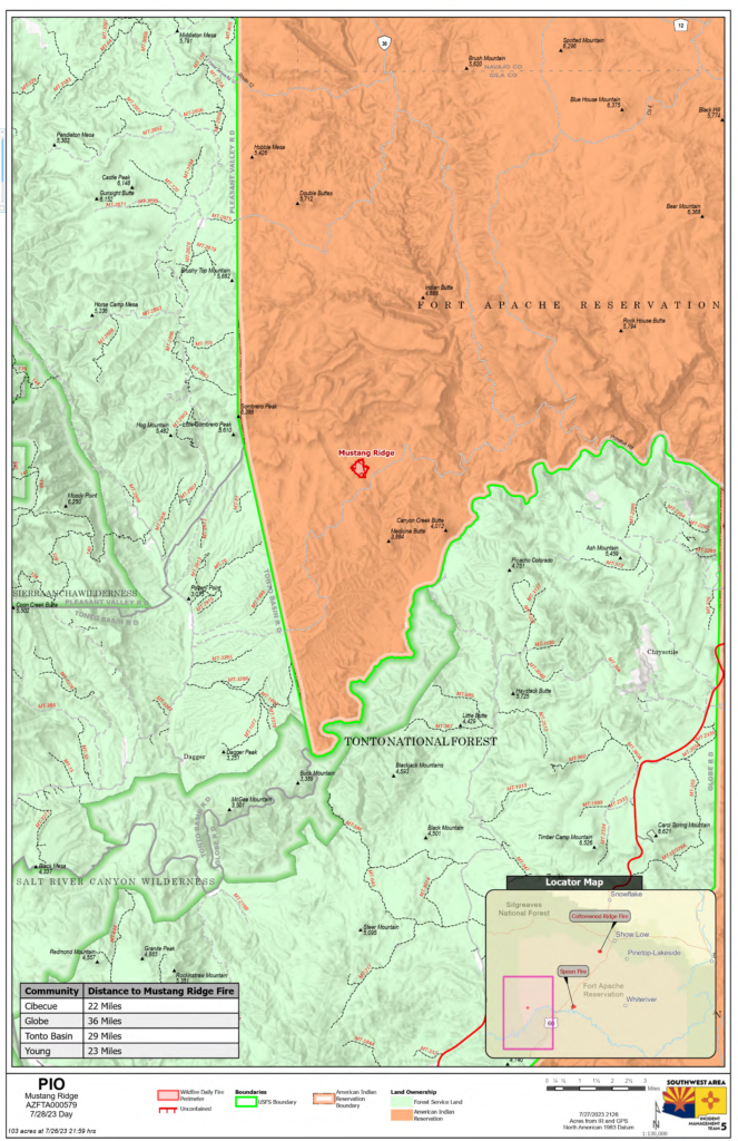
Mustang Ridge Fire Quick Facts
*Acres: 104
Cause: Lightning
Containment: 0%
Start Date: July 25, 2023
Location: 12 miles west of Highway 60 between Globe and Show Low, AZ. 11 miles southwest of Cedar Creek.
Fuels: Piñon- Juniper, Manzanita, Grass, Cedar
Total personnel for all incidents: 250
The Southwest Area Incident Management Team 5 assumed command of three fires — Cottonwood Ridge Fire, Mustang Ridge Fire and the Spoon Fire — on the Fort Apache Indian Reservation. Thank you for welcoming us to your community as we work to contain these fires.
Spoon Fire Update: Wednesday, the Spoon Fire, +30 miles south of Show Low, produced a large column of smoke in the afternoon that could be seen from Show Low. This was not smoke from the nearby Cottonwood Ridge Fire. Single-engine airtankers and one large airtanker dropped retardant on the west side of the Spoon Fire. After carefully considering the weather, and vegetation in the area, and potential threats, fire managers will actively suppress the westside of the fire to prevent movement towards Highway 60. On the east side of the fire, firefighters are looking for opportunity to safely contain the fire using roads, natural barriers and constructed fireline.
Cottonwood Ridge Fire Update: There was no growth on the Cottonwood Ridge Fire Wednesday. After more accurate infrared mapping, acres decreased from 411 to 345. The fire produced minimal heat and smoke. A type-1 helicopter dropped buckets of water on hotspots identified by firefighters on the ground. On Thursday, crews will continue to construct fire line directly at the fire’s edge on north side of the fire. Crews will also be securing fire line on the south/southwest side of the fire. Aerial resources will be available if needed.
Mustang Ridge Fire Update: The Mustang Ridge Fire did not grow Wednesday. There was minimal fire activity and smoke. Today, a crew will hike into the remote fire, addressing any remaining smoldering vegetation. Weather: Temperatures tomorrow will be in the upper 90s on the Cottonwood Ridge Fire. Light winds 5-10 mph are forecasted. There is a chance of rain tomorrow afternoon/evening as monsoonal moisture passes across parts of Arizona. The lower wind speeds will help decrease fire behavior on the Mustang and Cottonwood Fires.
Evacuations: None. Residence and visitors and should take this time to familiarize themselves with the Ready, Set, Go evacuation model. The three steps encourage Arizonans to get READY by preparing now for what threatens their community.
Additionally, sign up for the Navajo County Alert System at https://tinyurl.com/y4vwrasw.Smoke: Highway 60 will be impacted by smoke as the Spoon Fire continues to progress. Larger columns of smoke are more likely in the afternoon/evening. Please use caution when traveling along smoky roadways. For information on smoke and air quality visit https://www.airnow.gov.
Closures: There are no Highway closures in place. The southwest portion of Fort Apache is closed, including all Salt River sites within the closure area.
Fire Restrictions: There are several fire restrictions in place depending on location.• Fort Apache Agency: Stage 2 Fire Restrictions No campfires, fireworks, outdoor smoking, debris burning or discharging of firearms. Power saws cannot be used between 10 am and 8 pm. All motorized travel is restricted to developed roads.
Show Low, Navajo County and Apache Sitgreaves National Forest: Stage 1 Fire Restrictions No campfires (except in developed recreation sites), no smoking outdoors, no welding, no fireworks.
More Information: Inciweb: • Cottonwood Ridge: https://inciweb.nwcg.gov/inci…/azfta-cottonwood-ridge-fire • Spoon: https://inciweb.nwcg.gov/incident…/azfta-spoon-fire Facebook: https://www.facebook.com/BIAFAAFireMgt/ *Acres are determined by infrared flights that map the fire area overnight.
Public Information Line: 928-421-4579 Phone Line Hours: 8 am – 8 pm Email: 2023.CottonwoodRidge@firenet.gov
All reactions:99