Bush Fire Update, Monday, June 15, 2020
Gila County Sheriff has placed residents in Tonto Basin/Punkin Center in Go Status
Location: 22 miles NE of Mesa, AZ
Start date: Saturday, June 13, 2020
Cause: Human caused, vehicle fire
Size: 37,900 acres
Percent containment: 0%
Vegetation: Tall grass and brush
On Monday morning, June 15, 2020, the Gila County Sheriff’s Office placed Tonto Basin/Punkin Center from Highway 188 and A-Cross Road to Highway 188 at Rambo Realty in Go Status. This includes all residents on both sides of the highway, and both sides of the creek are now being asked to Go. Visit www.facebook.com/gilacohealthem/ for the latest information for residents living in these areas.
The Southwest Area Team Incident Management Team 5 assumed command of the Bush Fire from the Tonto National Forest this morning, freeing local firefighters to rest and be available for any new fire starts.
Fire activity: Last night the fire perimeter was mapped with the use of an infrared equipped aircraft, giving fire managers a more accurate fire size. The Bush fire was most active on the northeast side, moving toward Tonto Basin/Punkin Center. This growth was fueled by hot and dry weather, combined with an abundant crop of dry grass. A Bush Fire Facebook page has been set up and can be found at https://www.facebook.com/bushfireinfo The Southwestern Incident Management Team is being assisted by Tonto National Forest, Arizona Department of Forestry and Fire Management, Maricopa and Gila County Sheriffs Offices, Arizona Department of Transportation, Maricopa County Department of Transportation, Arizona Department of Public Safety, and SRP. No structures have been damaged. Infrastructure protection for State Highway 87, powerlines, private property, and sensitive recreation and heritage resources continue to be priorities for firefighting efforts. Smoke will continue to be seen in the east Phoenix metropolitan valley, with heavy smoke impacting the Tonto Basin and Roosevelt Lake areas, along with recreation sites along the lower Salt River.
Safety: Additional firefighters are arriving to assist with fire suppression efforts. Due to increased fire activity and increased personnel near Tonto Basin/Punkin Center, please stay away from State Highway 188 to allow residents to safely leave the area. The Beeline Highway, northbound State Route 87 remains closed at the intersection of Bush Highway and the southbound lanes of SR 87 is closed before the SR 188 junction. Please avoid these areas.
Weather: Hot and dry weather is expected for the next several days with winds out of the Southwest. Tuesday may bring red flag conditions which will cause additional challenges for firefighters.
Values: Fire fighter and public safety are the highest priorities on the Bush Fire. The fire area includes multiple communities, state highways, communication sites and power lines which firefighters are working hard to protect.
Road and Area Closures: Highway 188 between SR 87 and Globe is temporarily closed to allow for the safe travel of residents out of the area. State Route 87, Beeline Highway, is closed from the junction of Bush Highway to above the SR 188 junction near Payson. Please visit https://az511.com/ for current information about highway closures.
Recreation Closures: The roads leading to Sugarloaf, Four Peaks, Lower Sycamore, The Rolls, Pobrecito, Butcher Jones, Saguaro Del Norte, and Saguaro Lake are closed at this time. Remember, wildfires are a No Drone Zone. If You Fly, We Can’t!
Bush Fire InciWeb https://inciweb.nwcg.gov/incident/article/6773/51974/
Facebook https://www.facebook.com/bushfireinfo
Author Archives: Haley Nicoll
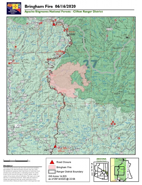
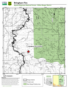
Bringham Fire Update 6.16.20
Fire spread slows as interior vegetation continues to burn
Bringham Fire – June 16, 2020 Daily Update

Acres: 14,625
Jurisdiction: Apache-Sitgreaves NF, Clifton Ranger District
Resources: 2 hotshot crews, 3 Type 2 initial attack crews, 4 Type 3 engines, 3 Type 6 engines, 5 water tenders, 1 Type 1 helicopter, 1 Type 2 helicopter, 1 Type 3 helicopter, miscellaneous overhead
Start Date: June 6, 2020
Percent Containment: 5%
Origin Location: 22 miles north of Morenci, AZ
Cause: Lightning
Personnel:
327
Scattered dry thunderstorms moved over the fire area yesterday, bringing a slight drop in temperatures and an increase in cloud cover. The increased humidity continued to moderate fire behavior, as minimal fire spread was observed. Although no significant activity was detected on the fire’s edge, interior pockets of vegetation continue to burn through the grass and brush beneath the forested canopy.
Increased cloud cover prevented the National Infrared Operations pilot from flying over the fire area last night. These pilots capture high resolution airborne infrared imagery and fire detection data that informs the acreage numbers reported to the public and fire managers. As a result of last night’s weather, no infrared mapping was completed therefore the reported acreage remains the same. The Incident Management Team will report updated acreage as soon as an infrared flight can be safely conducted.
Fire managers are working to identify strategic locations to hold the fire in place, including those areas previously burned in past wildfires where fuels are limited and the potential for fire spread is low. As they continue to monitor all sides of the fire, crews are prepared to conduct burnout operations if the fire approaches any areas of concern. Based on the predicted thunderstorm activity, firefighters do not expect to see a significant change in fire behavior today. An incoming drying trend is expected midweek, bringing rising temperatures and lower humidity over the fire area. Limited fire activity over the past few days has allowed firefighters to get ahead of the anticipated fire growth and prepare for the increased activity that may come with the rising temperatures.
For the protection of the public and our firefighters, Highway 191 is closed in both directions between Mile Marker 189 (just past Juan Miller Road) and Mile Marker 225 (Blue Vista). This closure will remain in place through June 21, 2020 and may be extended as firefighters continue to secure the road corridor. Fire personnel are using Highway 191 to travel to and from the incident, and to transport important supplies and equipment. Members of the public are advised to drive with caution and leave roadways clear for emergency vehicles and equipment to pass. More information can be found at https://azdot.gov/adot-news/us-191-closed-eastern-arizona-mountains-due-bringham-fire.
Fire Information Officers are available from 8:00AM to 8:00PM to respond to questions via phone at (928) 288-2154 or email at 2020.bringham@firenet.gov. Additional fire information can be found at the following links:
- InciWeb: https://inciweb.nwcg.gov/incident/6747/
- Facebook (updates and daily operational videos): https://www.facebook.com/apachesitgreavesnfs/
- Interactive Bringham Fire Map: http://www.fs.usda.gov/goto/BringhamFireWebMap
- Temporary Closure Order: https://www.fs.usda.gov/detail/asnf/alerts-notices/?cid=stelprd3793918
Bringham Fire Update 6.8.2020
NEWS RELEASE:
Bringham Fire, June 8, 2020
Location of Origin: Apache-Sitgreaves National Forests, Clifton Ranger District
Start Date: June 6, 2020 Size: Approximately 500 Acres
Cause: Lightning
Percent Contained: 0
Personnel: Approximately 95
Resources Assigned: 3 hotshot crews, 1 initial attack crew, 2 Type 6 engines, 2 water tenders, 1 Type 1 helicopter, 1 Type 3 helicopter, various incident management overhead.
The Bringham Fire was ignited by lightning on the Apache-Sitgreaves National Forests’ Clifton Ranger District on June 6, 2020. The fire has grown to approximately 500 acres and is burning in steep rugged terrain. During suppression efforts on Saturday and Sunday, firefighters successfully used retardant and helicopter water drops to slow the fires spread.
On June 7, the White Mountain Zone Type 3 Team, led by Incident Commander Matt Bullmore, assumed command of the Bringham Fire. The management objective is full suppression of the fire with the primary objective being firefighter and public safety. Values at risk include the Rose Peak lookout fire tower, private properties, and state highway 191. Concerns impacting fire suppression include Red Flag conditions, low relative humidity, high winds and competition for resources from other incidents. Fire fighters today will continue to monitor the north and east sides of the fire and will continue structure protection for the Rose Peak lookout fire tower, and aircraft will be utilized to check fire movement. Strong winds and instability are helping to lift the smoke out the area and disperse it to the northeast. Smoke may impact state highway 191, nearby communities and areas of western New Mexico.
Fuels prep and potential burnout operations are being planned to reinforce holding features and could bring smoke and fire close to Highway 191. To ensure public safety, the highway will be closed in both directions for seven days effective June 9, 2020. Timing of possible firing operation will be dictated by safety, weather, and operational progress. The closure will stretch from the Blue Vista overlook to mile-marker 189. ADOT signage will be in place near both blockades on Highway 191. Only owners or lessees of land within the area will be exempted from the highway closure.
Fire information can be found on InciWeb at https://inciweb.nwcg.gov/incident/6747/. Information about the Apache-Sitgreaves National Forests can be found at www.fs.usda.gov/asnf.

