NEWS RELEASE:
Bringham Fire, June 8, 2020
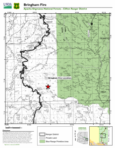
Location of Origin: Apache-Sitgreaves National Forests, Clifton Ranger District
Start Date: June 6, 2020 Size: Approximately 500 Acres
Cause: Lightning
Percent Contained: 0
Personnel: Approximately 95
Resources Assigned: 3 hotshot crews, 1 initial attack crew, 2 Type 6 engines, 2 water tenders, 1 Type 1 helicopter, 1 Type 3 helicopter, various incident management overhead.
The Bringham Fire was ignited by lightning on the Apache-Sitgreaves National Forests’ Clifton Ranger District on June 6, 2020. The fire has grown to approximately 500 acres and is burning in steep rugged terrain. During suppression efforts on Saturday and Sunday, firefighters successfully used retardant and helicopter water drops to slow the fires spread.
On June 7, the White Mountain Zone Type 3 Team, led by Incident Commander Matt Bullmore, assumed command of the Bringham Fire. The management objective is full suppression of the fire with the primary objective being firefighter and public safety. Values at risk include the Rose Peak lookout fire tower, private properties, and state highway 191. Concerns impacting fire suppression include Red Flag conditions, low relative humidity, high winds and competition for resources from other incidents. Fire fighters today will continue to monitor the north and east sides of the fire and will continue structure protection for the Rose Peak lookout fire tower, and aircraft will be utilized to check fire movement. Strong winds and instability are helping to lift the smoke out the area and disperse it to the northeast. Smoke may impact state highway 191, nearby communities and areas of western New Mexico.
Fuels prep and potential burnout operations are being planned to reinforce holding features and could bring smoke and fire close to Highway 191. To ensure public safety, the highway will be closed in both directions for seven days effective June 9, 2020. Timing of possible firing operation will be dictated by safety, weather, and operational progress. The closure will stretch from the Blue Vista overlook to mile-marker 189. ADOT signage will be in place near both blockades on Highway 191. Only owners or lessees of land within the area will be exempted from the highway closure.
Fire information can be found on InciWeb at https://inciweb.nwcg.gov/incident/6747/. Information about the Apache-Sitgreaves National Forests can be found at www.fs.usda.gov/asnf.

