
Cow Canyon Fire plus Trail Closure

Cow Canyon Fire September 8, 2020

Location of Origin: Apache-Sitgreaves National Forests, Alpine Ranger District

Start Date: August 18, 2020                           Size: Approx. 248 Acres

Cause: Lightning                                             Percent Contained: 10

Personnel: 0

Resources Assigned: 0

The Cow Canyon Fire, ignited by lightning on August 18, 2020 on the Alpine Ranger District, Apache-Sitgreaves National Forests, is burning in steep, rugged terrain, is in a remote location within the Blue Range Primitive Area and has minimal values at risk, therefore, is in Monitor Status. 

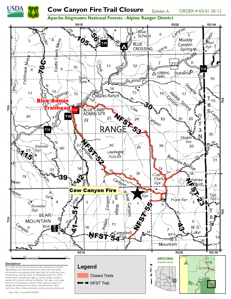
The Cow Canyon Fire, approximately four miles southeast of the Blue Camp in the Blue River Drainage, has grown to approximately 248 acres. The fire started on the north side of Lanphier Canyon and moved to the south crossing the canyon just to the west of Cashier Spring.

Franz Cabin and Corral are located to the east of the fire near Franz Spring. The fire will be monitored for movement to the east that may impact the cabin. Firefighters created a helispot near the cabin during the Whoa Canyon Fire in early July and will utilize that, if necessary, to help protect the cabin and corrals.

The Apache-Sitgreaves National Forests issued a temporary trail closure order effective today, September 8, 2020. The following trails are closed for public health and safety due to wildland fire activities along the trails:

Cow Flat Trail (#55) beginning at the trail junction of Bonanza Bill Trail (#23), following the Cow Flat Trail (#55) to the southwest until it meets the junction of WS Lake Trail (#54).

Lanphier Trail (#52) at the trailhead at the junction of National Forest Service Road (NFSR) 281, following the trail to the southeast until it meets Cow Flat Trail (#55).

South Canyon Trail (#53) at the trailhead at its junction with NFSR 281, following the trail to the southeast until it meets Cow Flat Trail (#55).

Smoke may be visible east of Hwy. 191 on the Alpine and Clifton Ranger Districts, west of Saddle Mountain, and near the town of Glenwood, New Mexico. Smoke-sensitive individuals and people with respiratory or heart disease are encouraged to take precautionary measures. Information on air quality and active prescribed burns can be found on Arizona Department of Environmental Quality’s webpage: https://azdeq.gov/.

For further information, please contact the Alpine Ranger District at 928-339-5000 or email Apache-Sitgreaves National Forests at as_portal_comments@usda.gov.
Lofer Fire Update

Lofer Fire and Flash Fire Update for September 08, 2020 

Lofer Fire Summary 
Location: 15 miles east of Whiteriver  Fire Cause: Lightning   Fire Size: 1,256 acres  Containment: 50%  Fuel Type: Timber, brush, litter  Resources: 133 incident personnel 

Lofer Fire: Yesterday afternoon, crews carried out firing operations along the K.L. Ridge which allowed firefighters to strengthen containment lines and promote a low intensity backing fire down Big Bonito Creek. Firefighters have begun to restore areas disturbed by containment and suppression efforts. This is being done to limit erosion along fire lines as well as to enhance the aesthetics of the landscape. Today, crews will be assessing if there is an additional need for firing operations while other resources will continue with suppression repair efforts. 

There will be a local type 3 organization transitioning tomorrow evening for the Lofer and Flash Fires. As containment continues to increase and fire activity decreases, the updates for the fire will only be posted to the BIA Forestry & Wildland Fire Management – Fort Apache Agency if there are any significant changes.  

Flash Fire: The Flash Fire is 51 acres in size and approximately 90 percent contained. 

Values and Objectives: Safety of incident responders and the public remains the number one priority. Incident personnel will continue to protect traditional gathering sites, recreation areas, the Mount Baldy Wilderness, commercial timberlands and watersheds, and continue to protect riparian areas to the Apache trout. 

Closures: For your safety and firefighter safety, please avoid the wildfire area and avoid access roads into the fire. An approximate ten-mile section of BIA 55 Road remains closed to the public.  

Smoke: Smoke from California fires has increased dramatically and will again move into Arizona. Gusty winds today should move lingering smoke out of the area. 

Important Reminders: Today, strong gusty winds are predicted, and we ask that everyone be careful with their campfires and extinguish it completely when you are leaving. Campfires are prohibited in undeveloped campgrounds and the public is reminded to be fire safe in developed campgrounds. Never leave a campfire unattended and be sure to drown your campfire with water and stir it up to suffocate any remaining heat.  

Fire information is available on the BIA Forestry & Wildland Fire Management – Fort Apache Agency at www.facebook.com/biafaafiremgt and on InciWeb at inciweb.nwcg.gov/incident/7093/  

Bringham Fire Update 6.18.20

High winds push the Bringham Fire northward

Bringham Fire – June 18, 2020 Daily Update

Acres: 17,423

Jurisdiction: Apache-Sitgreaves National Forest, Clifton Ranger District

Resources: 2 hotshot crews, 2 Type 2 initial attack crews, 3 Type 3 engines, 4 Type 6 engines, 6 water tenders, 1 dozer, 1 Type 1 helicopter, 1 Type 2 helicopter, 1 Type 3 helicopter, miscellaneous overhead

Start Date: June 6, 2020

Percent Containment: 5%

Origin Location: 22 miles north of Morenci, AZ

Cause: Lightning

Personnel: 315


Strong winds challenged firefighters on Wednesday afternoon as fire spread further north off Red Mountain and down into the southwestern side of Strayhorse Canyon. Smoke was more visible than it has been for the past several days, particularly in the afternoon when temperatures and winds reached their peak. Despite the visible smoke column, the main fire did not advance beyond the firelines constructed earlier this week. Helicopters lent support to the crews on the ground by dropping water buckets on the most active portions of the fire. A small fire spotted across Strayhorse Canyon but was quickly extinguished by the water buckets. Rappelers worked throughout the night to contain the small lightning-caused Pinal Fire that ignited on Tuesday evening, and plan to hike out today to rejoin the Bringham Fire crews.

Although wind speeds are expected to decrease to 16-19 miles per hour (MPH) with gusts of 25 MPH, fire managers anticipate continued fire movement to the north and east. Incident Meteorologists from the National Weather Service predict that the atmosphere will become increasingly unstable throughout the day with increasing sunshine in the afternoon that could increase terrain-driven winds. With this expected fire spread, crews are working to protect structures by covering nearby cabins in aluminum wrap to shield from radiant heat and embers, if the fire were to move further in their direction. Fire activity has moderated along Highway 191, although the potential remains for hot spots to spread as conditions dry out later in the week.

For the protection of the public and our firefighters, Highway 191 is closed in both directions between Mile Marker 189 (just past Juan Miller Road) and Mile Marker 225 (Blue Vista). This closure will remain in place through June 21, 2020 and may be extended as firefighters continue to secure the road corridor. Fire personnel are using Highway 191 to travel to and from the incident, and to transport important supplies and equipment. Members of the public are advised to drive with caution and leave roadways clear for emergency vehicles and equipment to pass. More information can be found at https://azdot.gov/adot-news/us-191-closed-eastern-arizona-mountains-due-bringham-fire.

Fire Information Officers are available from 8:00AM to 8:00PM to respond to questions via phone at (928) 288-2154 or email at 2020.bringham@firenet.gov. Additional fire information can be found at the following links: