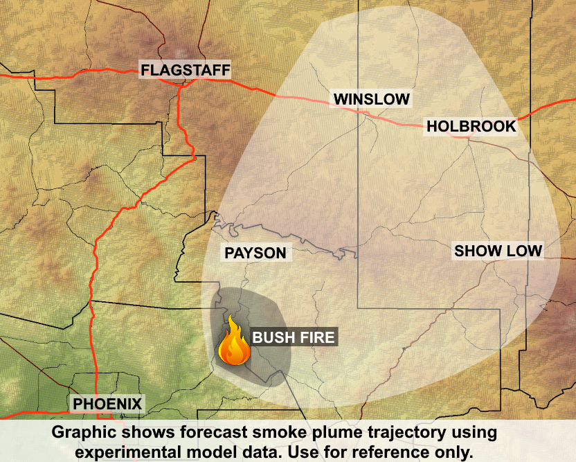
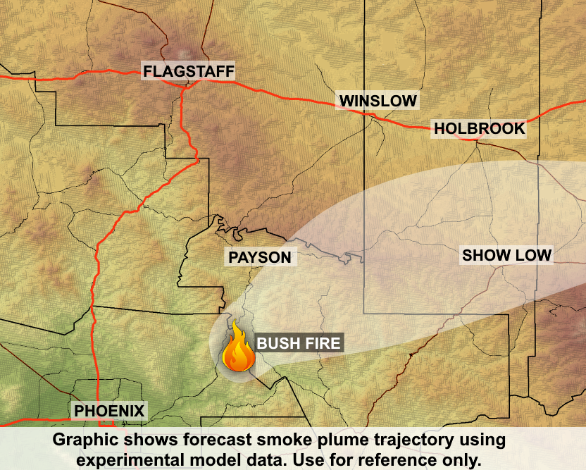
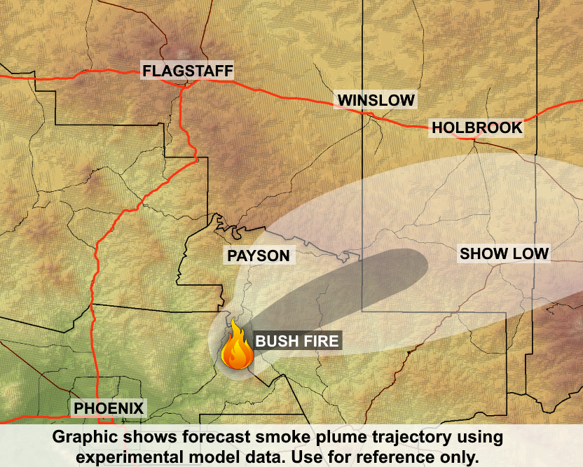
Bush Fire Update for June 21, 2020

Acres: 184,531 acres (based on infrared flight)
Percent Containment: 15%
Start Date: Saturday, June 13, 2020
Cause: Human-caused
Origin Location: 22 miles NE of Mesa, AZ
Fuels: Tall grass and brush
Resources: 846 total including 11 Type 1 Crews; 8 Type 2 Crews; 46 Engines; 5 bulldozers; 21 water tenders; 9 helicopters
Expect to See Fire and Smoke as Fuels Within the Bush Fire’s Perimeter Continue to Burn; Firefighters Also Responding to the Central Fire; Online Community Meeting 6pm Tonight
Yesterday firefighters brought fire off Mount Ord and tied it in to SR 87 on the northwest side of the fire. Firefighters will be holding the area today. Firefighters will continue to patrol and protect communities as needed.
Residents along the Highway 188 corridor should expect to see fire and smoke as fuels burn within the large pocket of unburned fuel within the fire’s perimeter. Interactive Bush Fire perimeter map: https://tinyurl.com/Bush-Fire-Map
Firefighters continue to use sing a range of tactics to fully suppress the fire. They are working to protect values at risk including nearby communities, state highways, communication sites and power lines.
The incident management team has assumed command of the Central Fire. https://inciweb.nwcg.gov/incident/6792/
There will be an online community meeting tonight on the Bush and Central Fires at 6 pm on Fb.com/bushfireinfo. An American Sign Language interpreter and captioning will be provided. A recording will be posted following the meeting.
No account is required to view the video. If a pop-up box appears when you first navigate to the link, you can use the scroll bar on the right to scroll down to the view and/or click “not now” to minimize the login pop-up. We will monitor online Facebook questions during the meeting or you can e-mail us your questions at 2020.bush@firenet.gov.
Sunflower and residents and visitors to Apache Lake remain under “Go” evacuation notice. The communities of Tonto Basin, Punkin Center, Pioneer Pass, Brownsville, Slate Creek, and Jake’s Creek have returned to “Set” mode. Gisela, Rye,
Deer Creek, 76 Ranch and Bar T Bar Ranch (BT Ranch) remain in “Set” status. Evacuation and shelter info map: https://tinyurl.com/bushfirepublicinfo. Visit Maricopa County https://ready.maricopa.gov/ and Gila County: www.readygila.com/ for more information.
Smoke Outlook: https://fires.airfire.org/outlooks/CentralArizona
Visit https://az511.com/ or call 511 for current road closure information. State Route 87 is closed from Payson (milepost 251) to Bush Highway (milepost 199). State Route 188 is closed between SR 87 (milepost 276) and Roosevelt Lake at milepost 243. In addition, State Route 88 is closed between Apache Lake (milepost 229) to State Route 188 (milepost 242). The long-term SR 88 closure from east of Tortilla Flat to Apache Lake also remains in effect.
The Tonto National Forest has an area closure surrounding the Bush Fire. Fire restrictions remain in place. Details are available at https://www.fs.usda.gov/alerts/tonto/alerts-notices.
Wildfires are a No Drone Zone. If you fly, we can’t. Every time a drone is spotted near the fire all aircraft are grounded until we can be sure the drone is clear of this area. More info visit http://knowbeforeyoufly.org.
Fire Information: 928-351-7596 (public) 928-351-7723 (media)
Inciweb: https://inciweb.nwcg.gov/incident/6773/ Facebook: Fb.com/bushfireinfo
Email: 2020.bush@firenet.gov Twitter: twitter.com/TontoForest
Inciweb.nwcg.gov

Bush Fire Smoke Impacts 6/21/2020

The Bush fire had one of its least active days yesterday, growing only by about 9,000 acres. The fire reached a total size of approximately 184,500 acres. According to satellite, the heaviest plumes of smoke remained over Gila County, just south of the Rim Country. But because of light winds over the region, smoke was able to slowly diffuse to the east, making for smoky skies over southern Apache and Navajo Counties. Locations including Payson, Heber, and Holbrook saw light to moderate smoke, not nearly as much as the previous 24 hours.

This morning on satellite, a thin layer of smoke can be seen extending across much of the region around the fire. This could be a combination of smoke from the Bush Fire and the Bighorn Fire, the latter which had sent smoke northward into Gila County yesterday. Holbrook has seen the greatest smoke impacts this morning; smoke is expected to lift out by 9 AM with the heating of the day.

Today, winds are forecast to be light over the fire again. Similar to yesterday, smoke is expected to slowly spread northward into the Rim Country through the morning and into the early afternoon. Then later in the afternoon, smoke is forecast to slowly spread out to the east-northeast, with light to moderate smoke possible in Heber, Holbrook, Show Low, and St. Johns. Smoke will continue to be visible to the north and/or northeast of Phoenix.

Overnight, winds will become mostly light, similar to previous nights, allowing smoke to settle in the Tonto Basin again, between Rye and Roosevelt Lake. But in general, smoke should be present around the region. Light smoke impacts may be possible in Fountain Hills. Any smoke that does fill into the low lying areas overnight is forecast to lift out by 9 am Monday.

On Monday, wind is expected to be light over the region again. Similar to today, smoke is forecast to move slowly north over Payson and Rim Country before moving to the east over Heber, Holbrook, Show Low, and St. Johns.