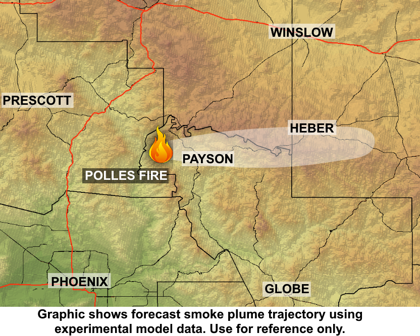
Bush Fire smoke impacts 6/23/2020

The Bush Fire grew by only about 140 acres yesterday, a far cry from activity observed over the weekend. It should be noted that the fire perimeter itself did not grow, but rather, interior pockets continued to burn. The total acreage of the fire is now estimated around 186,800 acres.

Unsurprisingly, far less smoke activity was seen on satellite yesterday. Only a couple small smoke plumes were noted in the afternoon, moving off to the east from the fire. However, a thin layer of smoke still remained over the region. Heber and Show Low saw some moderate smoke in the morning.

Looking ahead for today and tomorrow, smoke from the fire is expected to continue moving in the same general direction as previous days: it should disperse to the north into the Rim Country and toward Payson in the morning, then move off to the east in the afternoon. Then overnight, smoke is expected to settle into low-lying areas in/around the Tonto Basin area.

In general, smoke impacts are expected to be light across the region because of the significant decrease in fire activity. However, brief periods of light to moderate smoke impacts will be possible in Payson, Heber, and Show Low. Moreover, light impacts may be possible in Fountain Hills in the evening. Any smoke that does fill into the low lying areas near/around the fire overnight is forecast to lift out by 9 am Wednesday.

Bringham Fire – June 22, 2020 Daily Update

Acres: 20,845 acres
Jurisdiction: Apache-Sitgreaves National Forests, Clifton Ranger District
Resources: 2 hotshot crews, 3 Type 2 initial attack crews, 3 Type 3 engines, 3 Type 6 engines, 8 water tenders, 1 Type 1 helicopter, 1 Type 2 helicopter, 1 Type 3 helicopter, miscellaneous overhead
Start Date: June 6, 2020
Percent Containment: 20%
Origin Location: 22 miles north of Morenci, AZ
Cause: Lightning
Personnel: 308

Tomorrow, June 23 at 6:00AM, Carl Schwope’s Type 2 Incident Management Team will transition management of the Bringham Fire to the White Mountain Zone Type 3 Incident Management Team, led by Incident Commander Matt Bullmore. The White Mountain Zone Team managed the Bringham Fire prior to the Type 2 Team’s arrival on June 13. The number of personnel assigned to the fire will continue to decrease due to successful firefighting efforts.

“On June 11, the Bringham Fire doubled in size initiating the action for the Forest to order IMT Team 4. Firefighters began working quickly to keep the fire from spreading west of Highway 191. The location of the fire was remote and providing logistical support for the firefighters was the challenge for the IMT. The Forest had clear intent on the priorities for the fire which remained consistent throughout the incident. We appreciate the support from the local community with the closure of Highway 191 and providing water supply and lodging for the firefighters working night shifts,” said Incident Commander Carl Schwope.

Yesterday, the fire was again active in the interior unburned areas near Tin Cup Corral. These interior burns produced some smoke but did not contribute significantly to fire spread. The Lolo Hotshots successfully completed their mission to construct fireline with the goal of keeping fire on the south side of Strayhorse Creek. Using established dipsites, helicopters provided support to the firefighters by dropping water on remaining hot spots. The majority of fire activity in Strayhorse Canyon remains confined to the creek bottom. Some fingers have pushed north, however scabby fuels and terrain are helping to limit fire spread. Slow continued movement down canyon to the Blue River corridor is expected as temperatures rise.

Highway 191 remains closed in both directions between Mile Marker 189 past Juan Miller Road and Mile Marker 225 at Blue Vista. This closure will remain in place through June 27, 2020 and may be extended as needed. Fire personnel are using Highway 191 to transport crews, supplies, and equipment to and from the incident. Members of the public are advised to drive with caution and leave roadways clear for emergency vehicles and equipment to pass. More information can be found at https://azdot.gov/adot-news/us-191-closed-eastern-arizona-mountains-due-bringham-fire.

Fire Information Officers are available from 8:00AM to 8:00PM to respond to questions via phone at (928) 288-2154 or email at 2020.bringham@firenet.gov. Additional fire information can be found at the following links:
• InciWeb: https://inciweb.nwcg.gov/incident/6747/
• Facebook (updates and daily operational videos): https://www.facebook.com/apachesitgreavesnfs/
• Temporary Closure Order: https://www.fs.usda.gov/detail/asnf/alerts-notices/?cid=stelprd3793918
• Southwest Region Smoke Outlook: https://wildlandfiresmoke.net/outlooks/SouthwesternRegion
• Bringham Fire Interactive Story Map: https://nifc.maps.arcgis.com/apps/MapSeries/index.html?appid=014fe10eaaf44038bcf7ee1f3a1013e7

Bush Fire Smoke Impacts 6/22/2020


Find the wildfire smoke forecast at:
https://www.azdeq.gov/WildfireForecast

Find the Arizona air quality monitor report at
https://www.azdeq.gov/aq/monitorreport

The Bush fire was considerably less active yesterday than previous days, only growing by about 1,500 acres. The fire now has an estimated total size of a little more than 186,000 acres. According to satellite, smoke was spread out across the whole region, with the heaviest plume of smoke extending across Gila County, just south of the Rim Country, and penetrating westward into Maricopa County. But much of this proved to remain overhead, as monitors in Payson, Heber, and Holbrook observed light smoke for the most part, with periods of brief moderate smoke.

Today, winds are forecast to start out light and variable over the fire. Then by the afternoon, they’ll shift to out of the west. Similar to previous days, smoke is expected to initially spread northward into the Rim Country through the morning. Then in the afternoon, smoke is forecast to slowly spread out to the east, with light to moderate smoke possible in Heber, Holbrook, Show Low, and St. Johns. Smoke will continue to be visible to the north and/or northeast of Phoenix.

Overnight, winds will become mostly light, similar to previous nights, allowing smoke to settle into low-lying areas in/around the Tonto Basin. Light smoke impacts may be possible in Fountain Hills. Any smoke that does fill into the low lying areas overnight is forecast to lift out by 9 am Tuesday.

On Tuesday, winds over the fire are forecast to be light again. Smoke is forecast to move slowly north over Payson and Rim Country before moving to the east over/toward Heber, Holbrook, Show Low, and St. Johns.