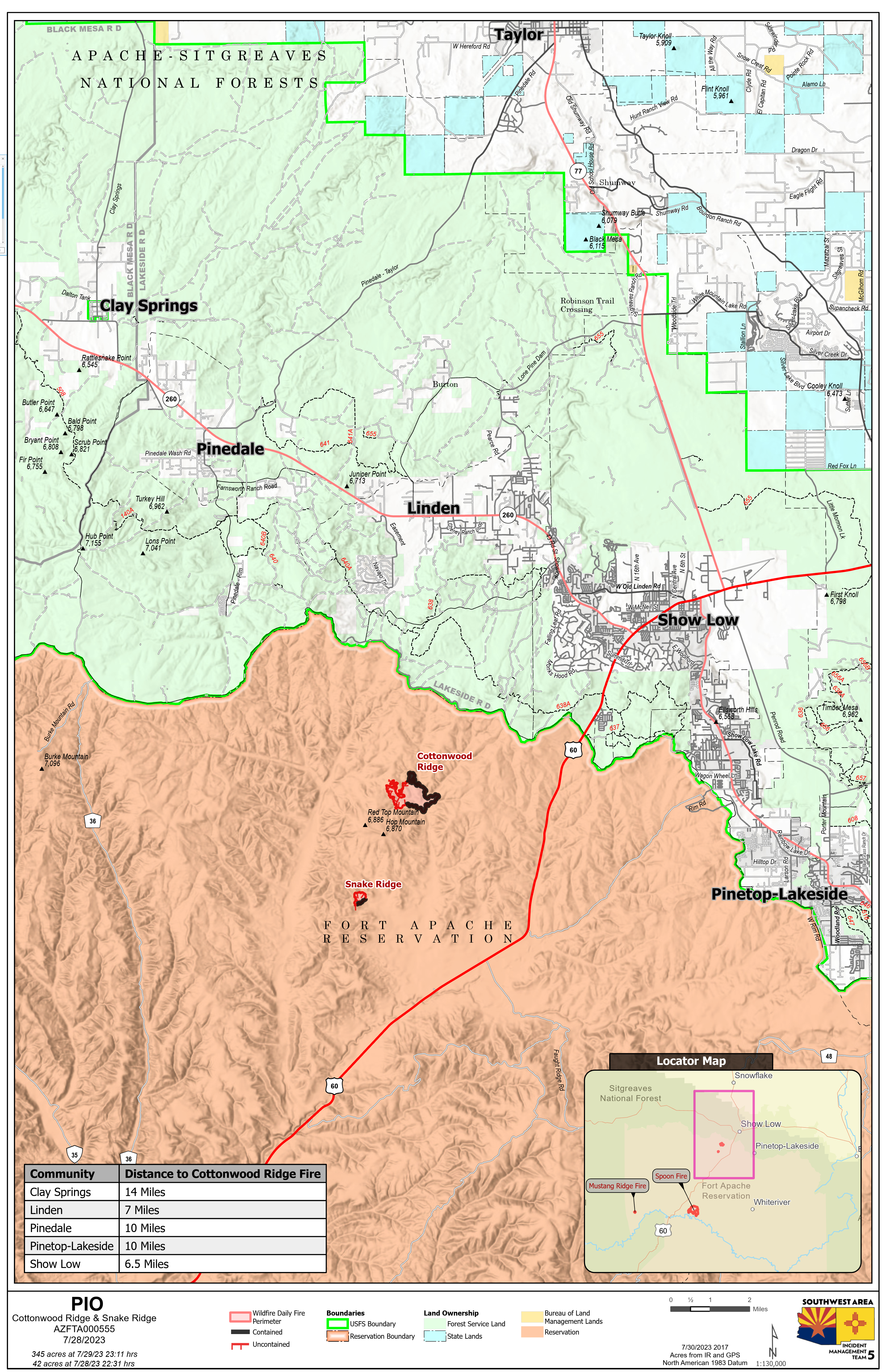
Cottonwood Ridge Fire Quick Facts
Acres: 345
Cause: Lightning
Containment: 50%
Start Date: July 23, 2023
Location: 4 miles south of Show Low, AZ
Fuels: Timber, grass, brush
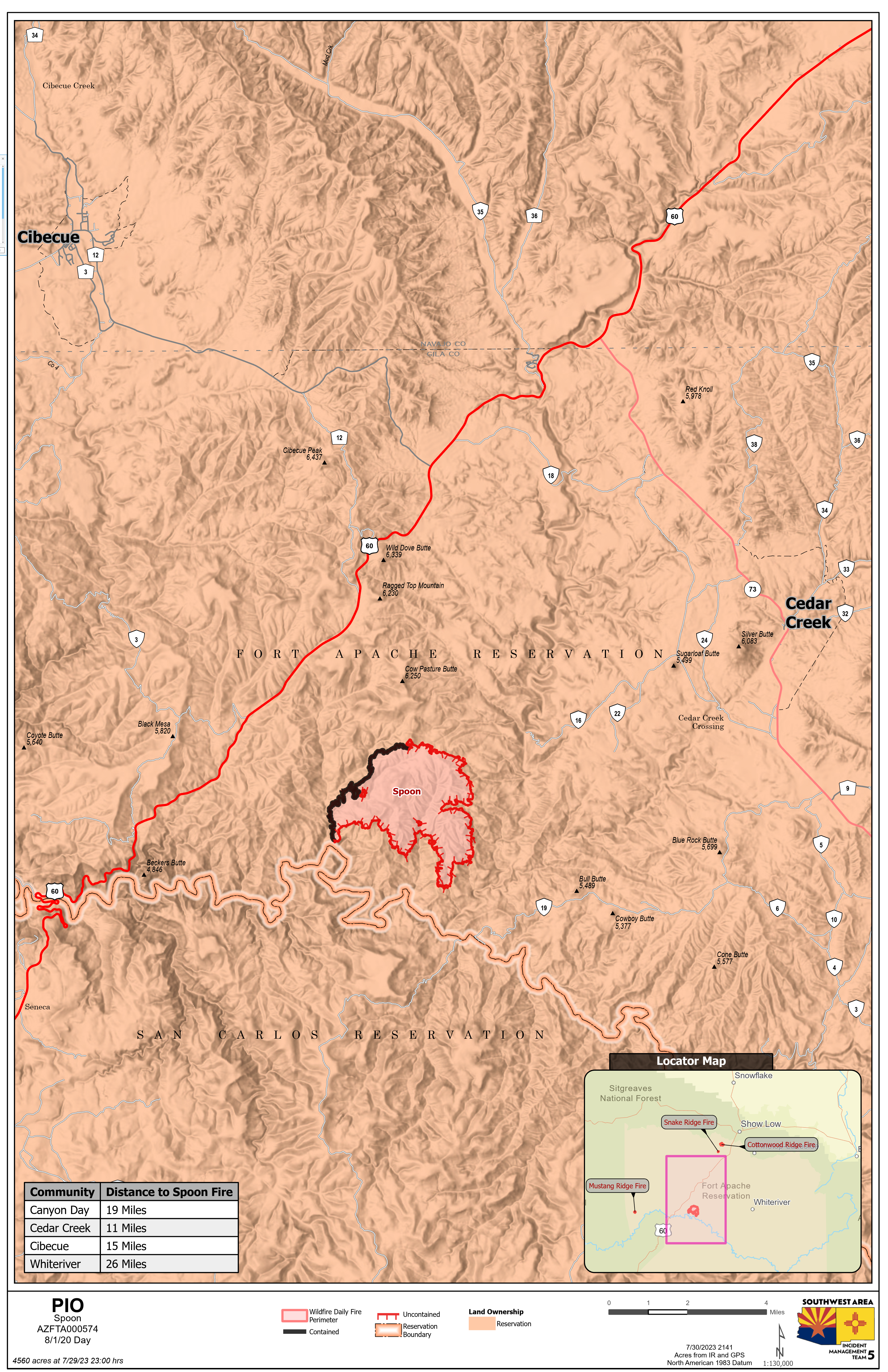
Spoon Fire Quick Facts
Acres: 4,560 acres
Cause: Lightning
Containment: 25%
Start Date: July 24, 2023
Location: 2.5 miles east of Highway 60 between Globe and Show Low, AZ. 11 miles southwest of Cedar Creek
Fuels: Pinon- Juniper, Manzanita, Grass, Cedar
Snake Ridge Fire Quick Facts
Acres: 42 acres
Cause: Lightning
Containment: 25%
Start Date: July 28, 2023
Location: 11 miles southwest of Show Low, AZ.
Fuels: Grass, Brush
Total personnel for all incidents: 392
Fire crews are making progress to contain all fires. Rain fell across the fire area, resulting in decreased fire activity. This will help keep fire activity minimal over the next few days. This doesn’t mean the fires are out.
Cottonwood Ridge Fire Update: Crews made progress bringing containment up to 50% before being forced off the fire line by rain and lightning. Crews will continue to improve and secure fire lines to protect communities to the north.
Spoon Fire Update: Fire crews gained containment along the west side and began direct fire line construction on the east side of the fire, resulting in containment increasing to 25%.
Snake Ridge Fire Update: No smoke was visible on the fire Sunday, and the fire showed minimal hot spots. Crews will continue to improve fire lines and mop up hot spots.
Weather: Rain fell across the area on Sunday, and all fires received some rain. Predictions for Monday include the possibility of thunderstorms forming and moving into the area in the early afternoon. Precipitation chances increase to 80%, with temperatures dropping into 80s.
Evacuations: None.
Residents and visitors should take time to become familiar with the Ready, Set, Go evacuation model. These steps help you to be READY in the event of an emergency by preparing now. Additionally, sign up for the Navajo County Alert System at https://tinyurl.com/y4vwrasw.
Smoke: The Spoon Fire may have isolated smoke from interior pockets of vegetation. Please slow down when traveling through smokey area. For information on smoke and air quality visit https://www.airnow.gov.
Closures: Highway 60 remains open.
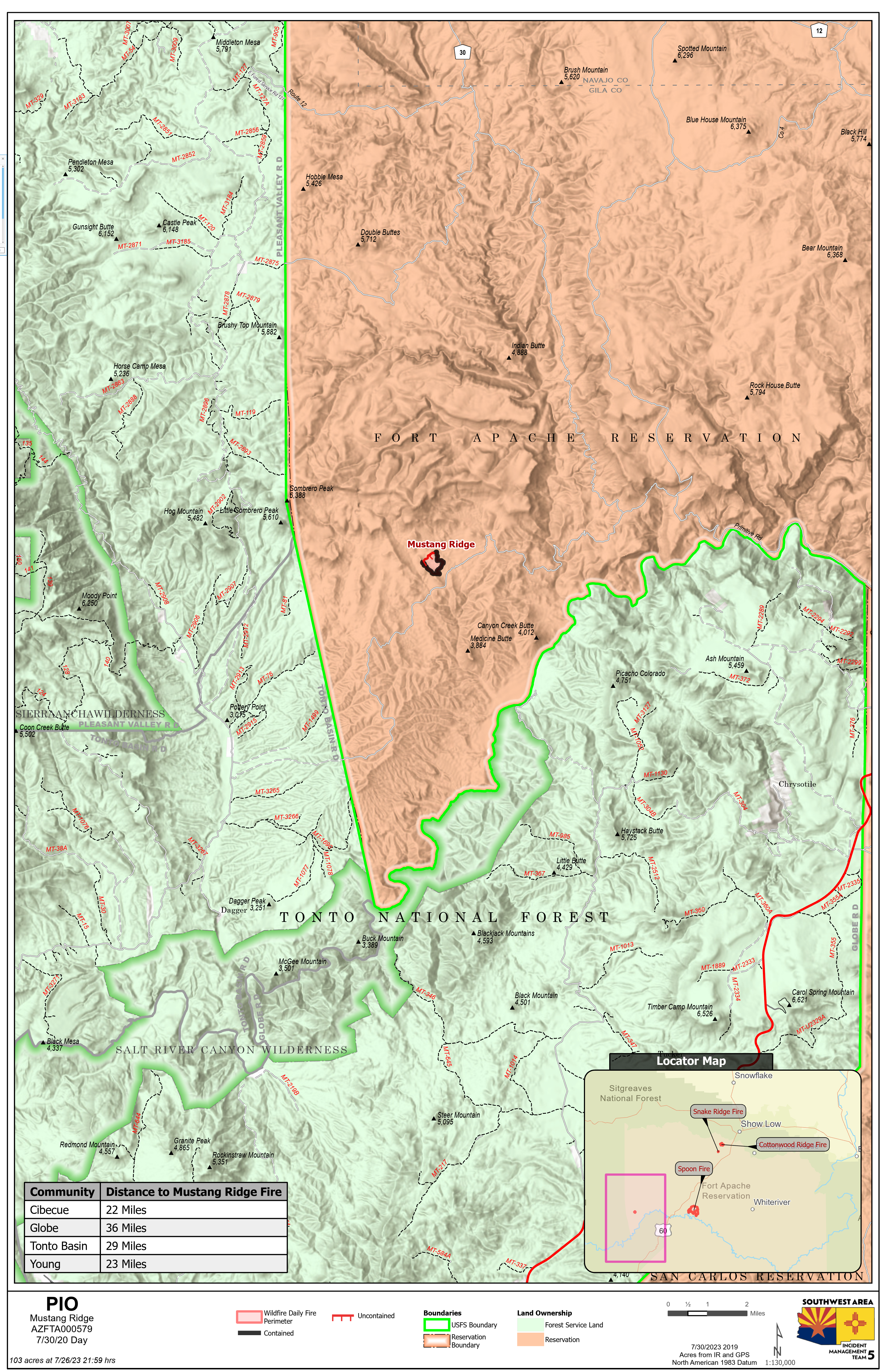
The southwest portion of Fort Apache is closed, including all Salt River sites within the closure area.Fire Restrictions:
There are several fire restrictions in place depending on location. Fort Apache Agency: Stage 2 Fire Restrictions. No campfires, fireworks, outdoor smoking, debris burning or discharging of firearms. Power saws cannot be used between 10 am and 8 pm. All motorized travel is restricted to developed roads.
Show Low, Navajo County and Apache Sitgreaves National Forests: Stage 1 Fire Restrictions. No campfires (except in developed recreation sites), no smoking outdoors, no welding, no fireworks.
For more Information visit Inciweb: For the Cottonwood Ridge fire: https://inciweb.nwcg.gov/inci…/azfta-cottonwood-ridge-fire For the Spoon fire: https://inciweb.nwcg.gov/incident…/azfta-spoon-fire
Facebook: https://www.facebook.com/BIAFAAFireMgt/