
Daily Update 6/23/2021
Announcement: The Wyrick Fire will host a virtual community meeting, Wednesday night, June 23, at 7:00 pm. Watch on Facebook at https://www.facebook.com/search/top?q=wyrick-west%20chev%20fire%20information
Overview: Clouds overnight prevented an Infrared Flight, so there is no updated acreage. Recent record breaking heat, combined with extreme drought conditions have set the stage for extreme fire behavior. Crews are working day and night to keep the Wyrick Fire from moving any closer to Heber-Overgaard. More favorable weather conditions will allow firefighters the opportunity to make some progress before sunny skies return.
Fire Update: On Tuesday, air tankers dropped retardant while helicopters dropped water on the southeast corner of the Wyrick Fire to keep the fire from moving to the south. Firefighters also worked on the south side of the Wyrick Fire between the 504 and 95 roads to construct fireline. The Wyrick fire is currently holding on the west side of Black Canyon. Firefighters were in place to begin assessing how to safely construct fireline to contain the West Chev Fire. Clouds helped to slow growth on both the Wyrick and West Chev fires yesterday afternoon.
Weather: Increasing cloud cover on Wednesday and Thursday, along with higher humidity will give firefighters a short window to make progress building fireline around the Wyrick Fire. Drought stressed plants and dead branches on the ground will still carry fire if pushed by winds. Winds will be out of the southwest Tuesday night and Wednesday, pushing fire away from Heber-Overgaard, although thunderstorms and gusty winds could quickly change the direction the Wyrick Fire moves.
Ready, Set, Go: There are no changes to the evacuation status. Visit Navajo County Emergency Management for additional information about the Ready, Set, Go program and how to sign up for alerts.
Areas in GO:
• Antelope Valley
• Despain Ranch
• Heber-and Overgaard north of State Routes 260 and 277
Areas in SET:
• Chevelon Retreat
• Communities south and east of State Route 277
• High Country Pines in Heber
• Kendall Ranch / Camp Ponderosa
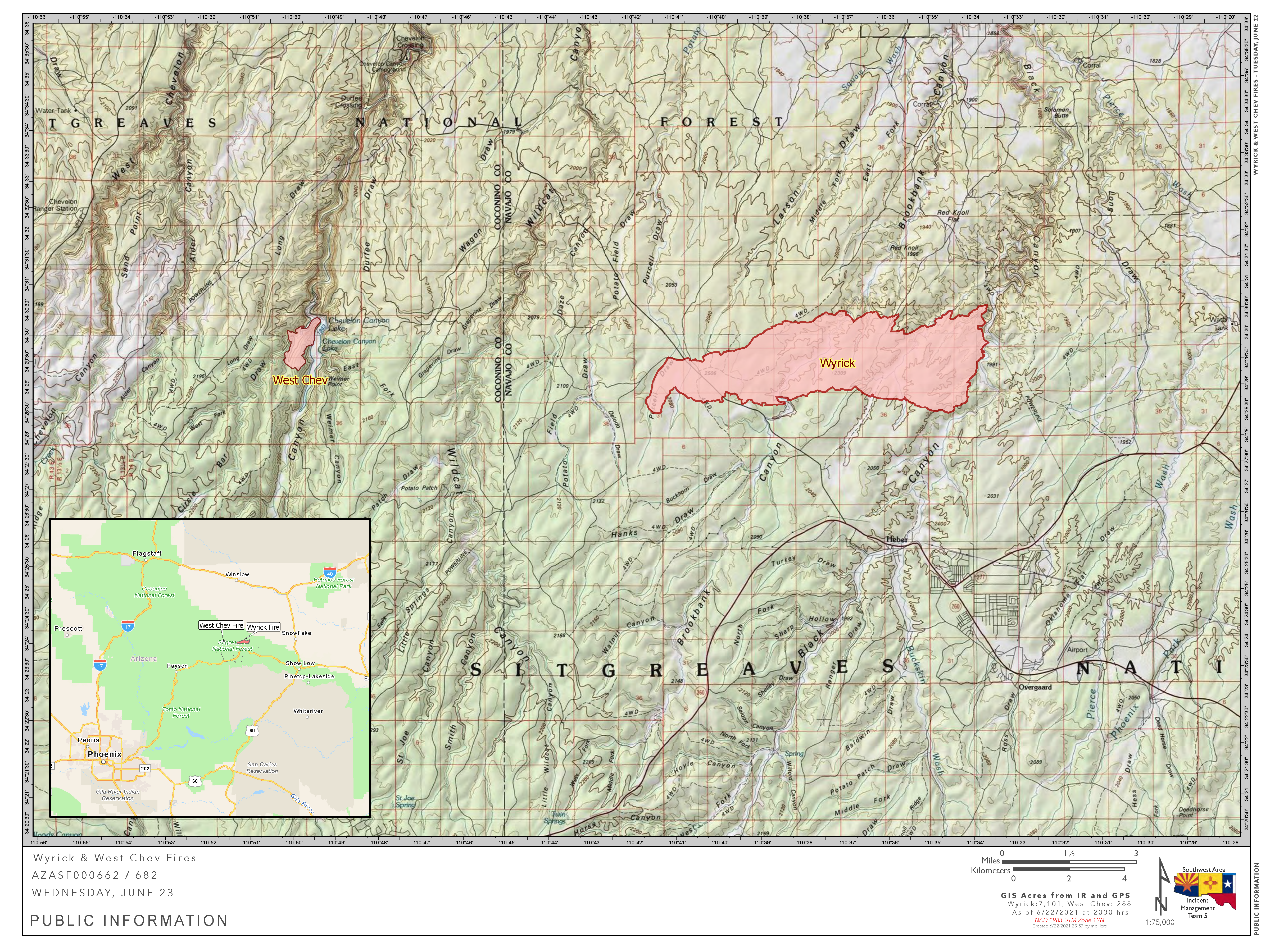
Acres: Wyrick: 7,101 acres
West Chev: 288 acres
Cause of Both Fires: Lightning
Containment: 0%
Personnel: 158
Start Date: Saturday, June 19, 2021
Location: Wyrick: 2 miles north of Tennyville HS, Heber, AZ
West Chev: 12.5 miles northwest of Heber, AZ
Fuels: Timber and grass
Areas in READY:
• Chevelon Ranches
Closures: The Apache-Sitgreaves national forests have announced a forest closure starting Thursday morning. The Black Mesa Ranger District implemented an emergency closure of the district west of Heber-Overgaard yesterday. Additional information can be found at Apache-Sitgreaves National Forests – News & Events (usda.gov). State Routes 260 and 377 have reopened heading into the Heber-Overgaard aera, according to the Arizona Department of Transportation. Continue to watch AZ511.gov for the latest updates.
Smoke: Smoke is visible and may settle into low lying areas overnight. The Daily Air Quality Index can be found by visiting Arizona Department of Environmental Quality at https://azdeq.gov/node/5914; or by downloading the Air Arizona mobile app on your smartphone. (https://azdeq.gov/airaz)
Values: Firefighter and public safety are the highest priorities on these fires. The fire areas include power lines and radio towers, private property, and natural resources.
More Information:
Inciweb:
• West Chev: West Chev Information – InciWeb the Incident Information System (nwcg.gov)
• Wyrick: Wyrick Fire Information – InciWeb the Incident Information System (nwcg.gov)
Wyrick-West Chev Fire Information: https://www.facebook.com/search/top?q=wyrick-west%20chev%20fire%20information
Apache-Sitgreaves National Forests: Apache-Sitgreaves National Forests – Home (usda.gov)Smoke: Wildfire Smoke Forecast | ADEQ Arizona Department of Environmental Quality (azdeq.gov)
Highway Closures: https://az511.gov/
Navajo County Emergency Management: https://www.navajocountyaz.gov/Departments/Emergency-Management-and-Preparedness/Ready-Navajo-County-Notification-System/Ready-Navajo-County-Registration
Navajo County Emergency Management Facebook: https://www.facebook.com/NavajoCountyEM/
Navajo County Sheriff’s Office: https://www.facebook.com/NCSO.AZ/posts/406098831395103