Daily Update 6/29/2021
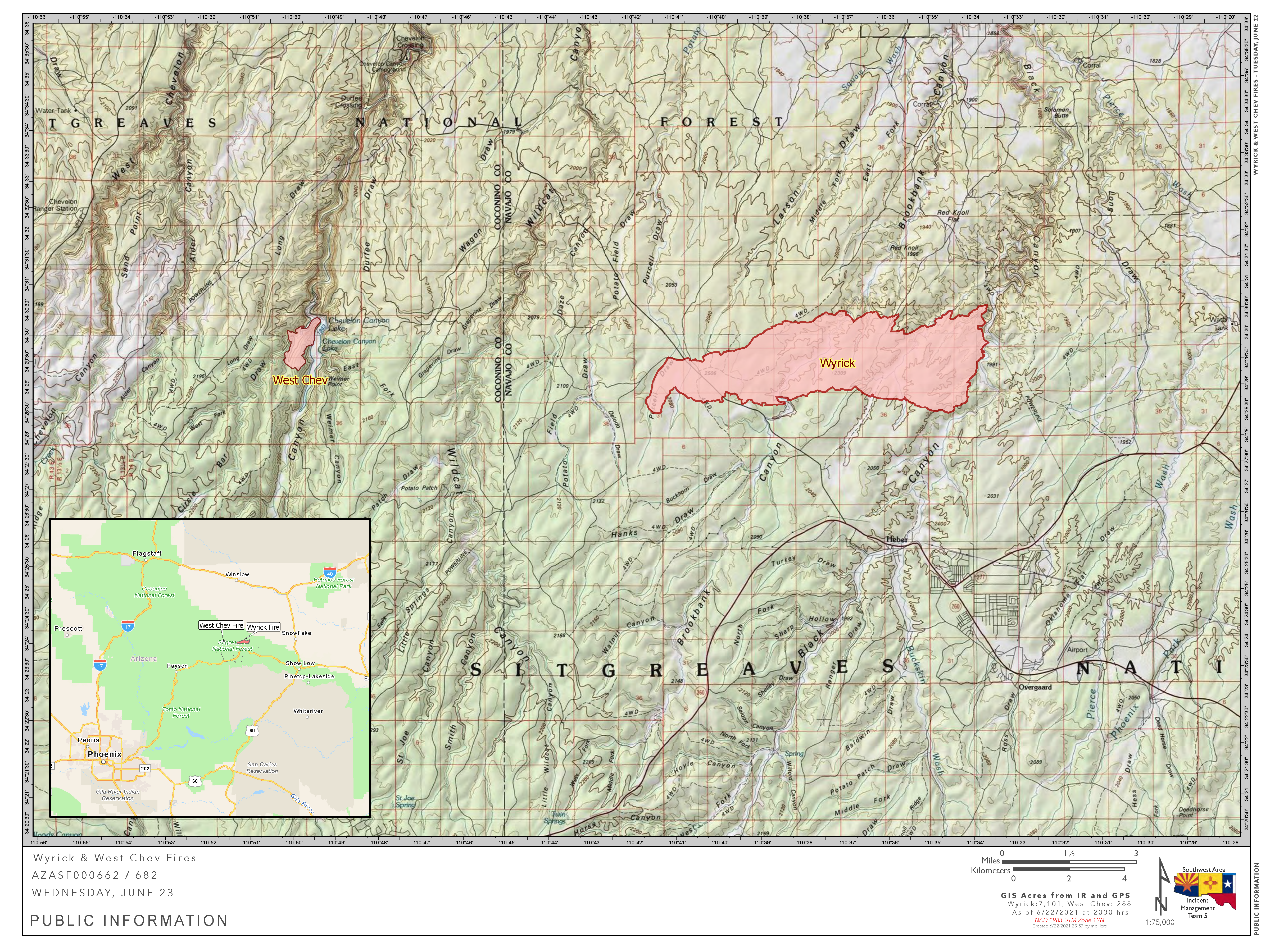
Wyrick
Start Date: Saturday, June 19, 2021
Acres: Wyrick: 7,592 acres
Cause: Lightning
Location: 2 miles north of Mogollon HS, Heber, AZ
Containment: 96%
Fuels: Pinyon-Juniper, Timber and grass
Total Personnel: 209
West Chev
Start Date: Saturday, June 19, 2021
Acres: 1,170 acres
Cause: Lightning
Location: 12.5 miles northwest of Heber, AZ
Containment: 85%
Fuels: Timber and grass
Announcement: This is the final Daily Update from Southwest Area Incident Management Team 5 (SWIMT 5) covering the Wyrick and West Chev fires. Management responsibility for the fires transitions back to the Black Mesa Ranger District at 6:00 PM tonight. SWIMT 5 wants to express our appreciation to the affected communities for their friendliness and overwhelming support throughout this effort.
For fire information after today, please call the Black Mesa Ranger Station at 928-535-7300 during normal business hours.
Overview: With containment on both fires at greater than 80 percent, management of the Wyrick and West Chev Fires transitions back to the local unit today. There is a 40 percent chance of rain on the fires today with more rain predicted over the next few days. Firefighters will monitor and patrol the fires today and reinforcement containment lines.
Fire Update:
Wyrick: Firefighters made good progress yesterday on the uncontained portions of the fire bringing overall containment up to 96 percent. This was a continuation of work done over the past few days with crews eliminating hotspots near containment lines. Light smoke could still be seen in internal areas. Infrared imagery from last night showed there are still areas of heat within the fire. So again today, firefighters will patrol and monitor the fire, looking for these areas of heat near the fire line. Efforts will be concentrated on the uncontained portions of the line in the northeast section of the fire.
West Chev: Yesterday, with an increase in relative humidity, the fire moved very slowly in Circle Bar draw. This is the only area where the fire is yet uncontained. As on the Wyrick fire, crews worked to extinguish hotspots and increase depth of containment lines. The fire will smolder today with only limited movement in Circle Bar Draw. Firefighters will again patrol the fire perimeter looking for hotspots which could threaten the line. In addition, they will be closely monitoring fire behavior in Circle Bar draw.
Weather: Moist air moved over the area yesterday and produced light rain showers. This afternoon, showers will develop over the Mogollon Rim and drift north over the fires. Chance of thundershowers today is 40 percent. Thunderstorms have the potential to cause gusty and erratic winds, which could blow ash into the air. Temperatures will be in the 70’s and 80’s with relative humidity percentages in the 30’s. This pattern will continue through the week.
Closures: A complete closure of the Apache-Sitgreaves National Forests remains in effect. Additional details can be found at Apache-Sitgreaves National Forests – News & Events (usda.gov). Arizona State Trust Lands in all 15 counties are closed for recreational use. For current information on highways, please continue to watch Arizona Department of Transportation’s AZ511.gov website.
Smoke: Very little smoke is expected from the Wyrick and West Chev Fires today. There are several other fires burning in Arizona right now. Information on these fires and their expected impacts to air quality can be found on inciweb at: https://inciweb.nwcg.gov. General smoke and air quality information for the state can be found on the Arizona Department of Environmental Quality website at: https://azdeq.gov/WildfireForecast.
Values: Firefighter and public safety are the highest priorities on these fires. Additional values at risk include properties and infrastructure, as well as power and transmission lines, communication towers, campgrounds, critical range infrastructure, and cultural and natural resources.
More Information:
Inciweb:
West Chev: West Chev Information – InciWeb the Incident Information System (nwcg.gov)
Wyrick: Wyrick Fire Information – InciWeb the Incident Information System (nwcg.gov)
Wyrick-West Chev Fire Information: (20+) Wyrick-West Chev Fire Information | Facebook
Apache-Sitgreaves National Forests: Apache-Sitgreaves National Forests – Home (usda.gov)
Highway Closures: https://az511.gov/
Navajo County Emergency Management: https://www.navajocountyaz.gov/Departments/Emergency-Management-and-Preparedness/Ready-Navajo-County-Notification-System/Ready-Navajo-County-Registration
Navajo County Emergency Management Facebook: https://www.facebook.com/NavajoCountyEM/
Navajo County Sheriff’s Office: https://www.facebook.com/NCSO.AZ/posts/4060988313951038
Fire Restrictions in Arizona: WildlandFire.AZ.gov/fire-restrictions