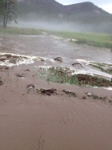
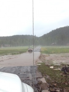
August 23, 2012 NWS Has Issued An Urban and Small Stream Flood Advisory For Apache and Navajo Counties. This includes the Wallow Fire Burn Area

AT 836 AM MST/936 AM MDT/…

National Weather Service Doppler Radar Indicated A Band Of Moderate To Heavy Rain Affecting Most Of Apache County…Moving Toward The East At 15 Mph. The Heaviest Rain Should Move East Of The Area By Around 10 Am Mst. Rainfall Amounts Of One Half To One Inch Of Rain Have Occurred In Many Areas…With Additional Rainfall Likely Through 10 Am Mst.
At 820 Am Mst/920 Am Mdt…Law Enforcement Reported Route 15 Near Mile Post 84 Between Ganado And Indian Wells Was Closed Due To Flooding. Flooding Will Be Possible In Many Other Areas Of Apache And Far Eastern Navajo Counties This Morning. Street Flooding Was Also Reported In Saint Johns.
The Wallow Burn Area Is Included In This Advisory. Days Of Heavy Rain Have Created Saturated Soils…And Additional Rain This Morning May Cause Some Flooding…Including Near The Communities Of Nutrioso And Alpine.
Precautionary/Preparedness Actions…
Most Flood Deaths Occur In Automobiles. Never Drive Your Vehicle Into Areas Where The Water Covers The Roadway. Flood Waters Are Usually Deeper Than They Appear. Just One Foot Of Flowing Water Is Powerful Enough To Sweep Vehicles Off The Road. When Encountering Flooded Roads Make The Smart Choice…Turn Around…Dont Drown.
Excessive Runoff Will Cause Flooding Of Creeks…Roads…And Normally Dry Washes. The Heavy Rains Will Likely Trigger Rockslides… Mudslides…And Debris Flows In Steep Terrain…Especially Near Recent Burn Areas Including The Wallow Burn Area.

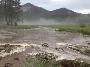
August 23, 2012 NWS Has Issued A Flash Flood Watch Until 5PM For Apache And Navajo Counties.

August 23, 2012

7:15 AM

…Flash Flood Watch In Effect Until 5 Pm Mst This Afternoon…


The National Weather Service In Flagstaff Has Issued A


* Flash Flood Watch For Portions Of North Central Arizona And

Northeast Arizona…Including The Following Areas…In North

Central Arizona…Eastern Mogollon Rim. In Northeast Arizona…

Black Mesa Area…Chinle Valley…Chuska Mountains And

Defiance Plateau…Little Colorado River Valley In Apache

County…Little Colorado River Valley In Navajo County…

Northeast Plateaus And Mesas Hwy 264 Northward…Northeast

Plateaus And Mesas South Of Hwy 264 And White Mountains.


* Until 5 Pm Mst This Afternoon


* A Moist And Unstable Air Mass Will Remain Across North Eastern

Arizona Through This Afternoon. An Upper Level Low Pressure

System Will Move Across The Area Bringing Widespread Showers And

Thunderstorms. Some Of These Thunderstorms Have The Potential To

Produce Very Heavy Rainfall And The Threat Of Flash Flooding.


* Persons In The Watch Area Should Be Alert For Water To Cover Low

Spots On Highways And Unimproved Roadways…Flash Flooding

Across Low Water Crossings…Flash Flooding Along Hiking Trails.

Remember Flash Floods Can Occur Within The Areas Of Heavy Rain

Up To 50 Miles Down Stream Away From The Heavy Rain. Avoid

Camping And Hiking In Flash Flood Prone Areas.