Jurisdiction: Tonto National Forest, AZ State Land, AZ-BLM, National Park Service
Size: 123,263 Percent Contained: 48%
Personnel: 836
Cause: Human-Caused, Under Investigation
Fire Information Line: 505-399-2439 7 a.m. – 9 p.m.
Email: 2019.woodbury@firenet.gov
Website: https://inciweb.nwcg.gov/incident/6382
Facebook: www.facebo tionalForest/
Twitter: @TontoForest
Personnel used an Unmanned Aircraft System (UAS) to fly over the eastern border of the fire to scout for hotspots. The UAS detected heat within the fire perimeter and helicopters were ordered for bucket water drops in addition to firefighters building line on the ground. The UAS continues to be used today.
On the northern perimeter, retardant drops were used to assist ground crews near Pinyon Mountain as vegetation continued to burn. The successful operation will be checked today to confirm the fireline is holding.
South of Highway 88, firefighters continue to secure fireline where burnout operations were conducted. Fire is still burning inside the fire area along the ridgeline of Fish Creek Canyon and parallel to the Arizona National Scenic Trail. For these reasons, Highway 88 remains closed from Tortilla Flat to the State Route 188 Junction.
There are still interior pockets of vegetation within the fire perimeter that will continue to burn but do not pose a threat to the firelines. The expected increased winds will make smoke noticeable throughout the week.
Crews resume suppression repair along the southern border where they are repairing dozer lines, chipping downed trees and hauling out debris. The repair is intended to help the area recover quicker and minimize the effects caused by fire operations.
As residents repopulate the Roosevelt area, crews continue to fully secure the northeastern perimeter of the fire. Residents should drive with caution as fire crews continue work along the roadway of the Highway 188 corridor. Recreation south of Highway 188 is still prohibited with the Forest Closure Order in effect.
Current closures:
Tonto National Forest Fire Area Closure information: https://bit.ly/31O2Ih4 Tonto National Forest Stage 1 Fire Restrictions remain in place. Tonto National Monument is closed. For current Arizona Department of Transportation information visit: https://az511.gov/

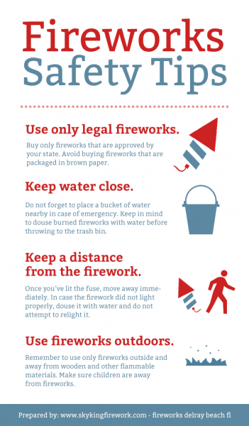
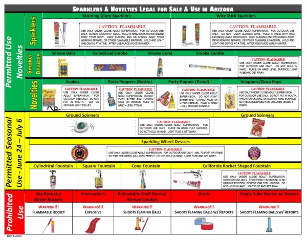 This 4th of July keep in mind that there might be items available to purchase but they may NOT be allowed to be used. We want all of our citizens and visitors to have a safe and enjoyable holiday so please take the utmost caution if you chose to use any of the permitted items. Maintain a close watch on all children when using, keep extinguishing equipment close and when in doubt leave it to the professionals! There are many opportunities throughout the region to view fireworks displays.