Bringham Fire – June 15, 2020 Daily Update

Jurisdiction: Apache-Sitgreaves National Forests, Clifton Ranger District
Resources: 4 hotshot crews, 2 initial attack crews, 2 Type 6 engines, 6 water tenders, 1 Type 1 helicopter, 1 Type 2 helicopter, 1 Type 3 helicopter, miscellaneous overhead
Start Date: June 6, 2020
Percent Containment: 5%
Origin Location: 22 miles north of Morenci, AZ
Cause: Lightning
Personnel: 304

Increased humidity and cooler temperatures carried in by surrounding thunderstorms helped to limit fire spread yesterday. Firefighters will continue to stay alert for increased thunderstorm activity, including any new lightning-caused fire starts, as the chance of precipitation grows to 25% today. Incident meteorologists indicate that a series of storms may move over the fire area today, bringing conflicting winds that could push the fire in multiple directions. Critical fire weather is possible later in the week as weather patterns shift to bring higher temperatures and drier conditions.

With the cooler temperatures moderating fire behavior, firefighters were able to begin assessing the risks to structures, including several cabins and ranch houses in area. A helicopter repel crew was flown into the Blue River corridor to begin structure protection efforts and create defensible space around the cabins. Future protection measures may include using aluminum structure wrap to protect the buildings from radiant heat and embers, if the fire were to move further in their direction.

The fire remains most active in the area around Red Mountain, burning through grasses and brush that make up the understory layer of timber forests. Firefighters are scouting for natural features such as ridgelines, trails and areas with exposed rock and sparse vegetation that could serve as holding lines. As crews monitor fire activity along Highway 191 and the area around Rose Peak, helicopters may assist ground crews by dropping water buckets to cool the fire’s edge. Crews continue to make progress along the highway, extinguishing any fires that threaten to cross over to the western side.

For the protection of the public and our firefighters, Highway 191 is closed in both directions between Mile Marker 189 (just past Juan Miller Road) and Mile Marker 225 (Blue Vista). This closure will remain in place through June 21, 2020 and may be extended as firefighters continue to secure the road corridor. Motorists should adjust travel plans accordingly. More information can be found at https://azdot.gov/adot-news/us-191-closed-eastern-arizona-mountains-due-bringham-fire.

Fire Information Officers are available from 8:00AM to 8:00PM to respond to questions via phone at (928) 288-2154 or email at 2020.bringham@firenet.gov. Additional fire information can be found at the following links:
• InciWeb: https://inciweb.nwcg.gov/incident/6747/
• Facebook (updates and daily operational videos): https://www.facebook.com/apachesitgreavesnfs/
• Interactive Bringham Fire Map: http://www.fs.usda.gov/goto/BringhamFireWebMap
• Temporary Closure Order: https://www.fs.usda.gov/detail/asnf/alerts-notices/?cid=stelprd3793918
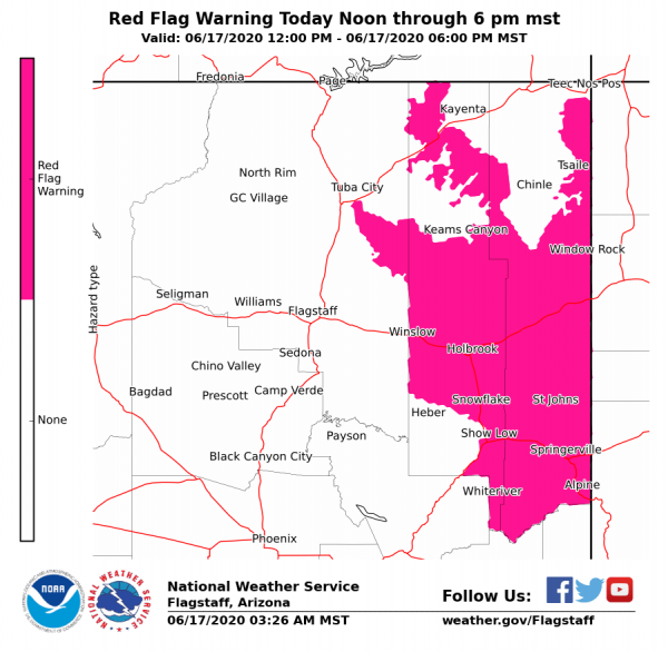
Southwest Region Smoke Outlook: https://wildlandfiresmoke.net/outlooks/SouthwesternRegion

NEWS RELEASE: Bringham Fire, June 12, 2020

Location of Origin: Apache-Sitgreaves National Forests, Clifton Ranger District
Start Date: June 6, 2020
Size: Approximately 10,803 Acres
Cause: Lightning
Percent Contained: 0
Personnel: 180
Resources Assigned: 4 hotshot crews, 1 initial attack crew, 3 Type 6 engines, 1 Type 3 engine, 2 water tenders, 1 Type 1 helicopter, 1 Type 2 helicopter, 1 Type 3 helicopter, various incident management overhead.

Thunderstorm Winds Push Bringham Fire

A thunderstorm moved into the area on Thursday producing strong erratic outflow winds, pushing the head of the fire to the northwest. As the fire progressed toward a trigger point near the Rose Peak lookout facility, fire crews began burnout operations to keep the fire east of Highway 191. Fire managers worked closely with the National Weather Service office in Tucson who provided the team with real-time tracking of the thunderstorm system, which was crucial in informing on-the-ground tactical decisions.

The weather for the Bringham fire is calling for dry thunderstorms today with gusty and erratic winds up to 35 miles per hour. The Bringham Fire is burning in steep, remote, inaccessible terrain, and erratic winds continue to push the fire North, West and Southwest, and continues to threaten US 191/Coronado Trail.

Burnout operations will continue today as needed if the fire reaches established trigger points along Highway 191. Burnout operations can produce large amounts of smoke, and although these tactics are vital to successful firefighting operations, smoke from wildfires can be hazardous to your health. The Arizona Department of Environmental Quality operates a network of portable particulate monitors across Arizona so that anyone can view air quality by visiting their website at https://www.phoenixvis.net/ppmmain.aspx.

Due to the increased complexity of the Bringham fire, a Type 2 Southwest Incident Management Team will be assuming command of the Bringham Fire at 0600 on Saturday, June 13.

A temporary Closure Order has been implemented for the Bringham fire and can be accessed at https://www.fs.usda.gov/detail/asnf/alerts-notices/?cid=stelprd3793918. Highway 191 is closed in both directions between mile-marker 189 (just past Juan Miller road) and mile-marker 225. More information can be found at https://azdot.gov/adot-news/us-191-closed-eastern-arizona-mountains-due-bringham-fire.

Fire information can be found on InciWeb at https://inciweb.nwcg.gov/incident/6747/. Information about the Apache-Sitgreaves National Forests can be found at www.fs.usda.gov/asnf.

Bringham Fire Update for 6.11.2020

Aside

Location of Origin: Apache-Sitgreaves National Forests, Clifton Ranger District

Start Date: June 6, 2020              

Size: Approximately 4,800 Acres

Cause: Lightning                             

Percent Contained: 0                                                                  

Personnel: 166 

Resources Assigned: 3 hotshot crews, 1 initial attack crew, 3 Type 6 engines, 1 Type 3 engines, 2 water tenders, 1 Type 1 helicopter, 1 Type 2 helicopter, 1 Type 3 helicopter, various incident management overhead.

Wildfire Movement Triggers Burnout Operations

Driven by wind and terrain, the Bringham fire reached a predetermined trigger point at Red Mountain Overlook on Wednesday. In response, firefighters conducted planned burnout operations along Highway 191 to keep the approaching fire front in check and keep the fire to the east of the highway. Values at risk that have been identified include the highway, area cabins, Rose Peak lookout, campground sites, natural and cultural resources, and threatened and endangered species and their habitat.  

The Bringham fire is expected to experience isolated showers and thunderstorms today and Friday, although forecasts aren’t calling for much relief in the form of rainfall. Thunderstorms can produce gusty and erratic winds and can cause fire to spread in all directions, and fire managers are prepared for this weather event.

Burnout operations will continue today if the fire reaches established trigger points along Highway 191, and portable water tanks have been set up along the highway to support helicopter resources in this effort. Burnout operations can produce large amounts of smoke, and although these tactics are vital to successful firefighting operations, smoke from wildfires can be hazardous to your health. The Arizona Department of Environmental Quality operates a network of portable particulate monitors across Arizona so that anyone can view air quality by visiting their website at https://www.phoenixvis.net/ppmmain.aspx.

A temporary Closure Order has been implemented for the Bringham fire and includes some forest roads, trails, day-use area facilities, and one campground. The closure order document and map can be found at https://www.fs.usda.gov/detail/asnf/alerts-notices/?cid=stelprd3793918. The public is reminded that Highway 191 is closed in both directions between mile-marker 189 (just past Juan Miller road) and mile-marker 225. More information can be found at https://azdot.gov/adot-news/us-191-closed-eastern-arizona-mountains-due-bringham-fire.

Fire information can be found on InciWeb at https://inciweb.nwcg.gov/incident/6747/. Information about the Apache-Sitgreaves National Forests can be found at www.fs.usda.gov/asnf.