A Red Flag Warning is in effect for much of Apache and Navajo County- Please be advised, there is NO burning on Red Flag days. Please postpone debris burns until weather is more conducive for burning.
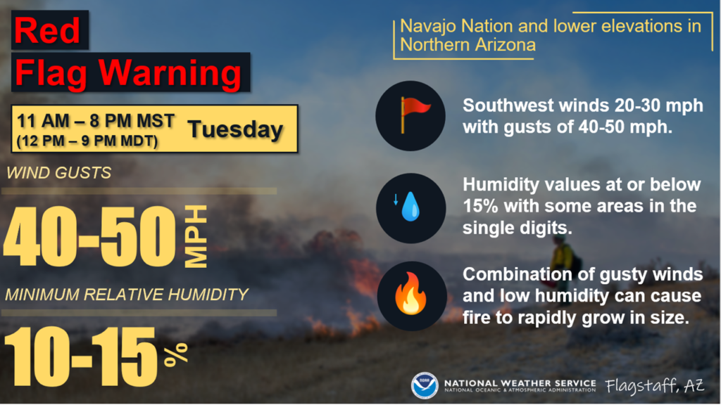

A Red Flag Warning is in effect for much of Apache and Navajo County- Please be advised, there is NO burning on Red Flag days. Please postpone debris burns until weather is more conducive for burning.
 Springerville, AZ, April 15, 2022 — The Clifton Ranger District on the Apache-Sitgreaves National Forests is planning to proceed with the Mesa Re-Entry prescribed burn project beginning as soon as Monday, April 18th and activity could extend through the end of the month as conditions allow.
The Mesa Re-Entry prescribed burn project is spread across approximately 8,000 acres, and smoke will be expected to be seen through the month of April, depending on weather conditions. The project area is bounded to the north and west by Pine Flat Road (FR 515), to the south by Upper Eagle Creek Road (FR 217), and to the east by sections of Corral Creek and Sheep Wash Canyon.
Public safety notices will be posted in the vicinity of the project, and travelers should use caution when in the area. Fire planners expect to take advantage of forecasted cool temperatures and lower winds in the coming days, and the project area will include a comprehensive safety strategy including control features and pretreating vulnerable areas.
Prescribed fires like the Mesa Re-Entry project are part of the Forest Service’s comprehensive 10-year strategy for protecting communities and improving resilience in America’s forests. The intent of the Wildfire Management Strategy is to increase fuels treatments that help firefighters respond safely to incidents, restore and maintain resilient landscapes, and create fire-adapted communities. The plan calls for treating up to an additional 20 million acres of National Forest System lands, and up to an additional 30 million acres of other federal, state, tribal and private lands.
Smoke is expected to be visible along Highway 191, Morenci and the community of Eagle Creek but is not expected to impact travel. Smoke-sensitive individuals and people with respiratory or heart disease are encouraged to take precautionary measures. Information on air quality and active prescribed burns can be found on Arizona Department of Environmental Quality’s webpage: https://azdeq.gov/.
The public can obtain additional information by calling the Clifton Ranger District at (928) 687-8600.
Stay up to date on news from the A – S at our website https://www.fs.usda.gov/asnf, on Twitter @A_SNFs and on facebook.com/apachesitgreavesnfs.
###
USDA is an equal opportunity provider, employer and lender.
Rehabilitation to Hermosa Drive Bridge over I-40 in Holbrook to begin in April.
Drivers can expect weekly night work for life of project Construction on the Hermosa Drive Bridge over Interstate 40 in Holbrook will begin on April 5. Drivers can expect daytime and nighttime restrictions, including periodic overnight full closures of I-40 during the project.
The first full closure of I-40 is scheduled from 9 p.m. to 5 a.m. on Tuesday, April 5. Additional nightly closures in April include April 7-9; April 11-15; and April 18-20.A detour will be in place using State Route 77 (known locally as Navajo Boulevard) when the I-40 full closures are in effect.
•Eastbound drivers will use Exit 286, proceed eastbound on Navajo Boulevard and then re-enter eastbound I-40 at Exit 289.
•Westbound drivers will use Exit 289, proceed westbound on Navajo Boulevard and then re-enter westbound I-40 at Exit 286.Additional overnight closures of I-40 are planned throughout the summer.
The bridge will receive a new bridge deck, guardrails and barriers. The roadway approaches to the bridge will be improved as well. The project is expected to be completed by this fall.
This bridge project continues ADOT’s commitment to invest in the I-40 corridor as a vital highway for commerce. From 2016 to 2020, ADOT invested more than $275 million on the roadway.For more information on this project, visit azdot.gov/projects and click on the Northeast District.I-40 Hermosa Drive Bridge Rehab Detour Project Map Schedules are subject to change based on weather and other unforeseen factors. For more information, please call the ADOT Bilingual Project Information Line at 855.712.8530 or go to azdot.gov/contact and select Projects from the drop-down menu. For real-time highway conditions statewide, visit ADOT’s Traveler Information Site at www.az511.gov, Need to know where a milepost is? Click on the “Mile Markers” icon on the map at www.az511.com. Follow ADOT on Twitter (@ArizonaDOT) or call 511, except while driving.