Upcoming Prescribed Burning within the Hop-Cot and Coyote West Burn Units

October 5, 2023
Whiteriver, AZ – The Bureau of Indian Affairs Fort Apache Agency Fire Management in coordination with the White Mountain Apache Tribe are planning to conduct prescribed burning within the Hop-Cot and Coyote West burn units on Tuesday, October 10, 2023. If conditions are favorable, active ignitions will continue for several days.

The Hop-Cot burn unit is located approximately 8 miles southwest of Show Low, Arizona and just west of Forestdale. The burn unit is 5,451 acres and active ignition will take several days.
The Coyote West burn unit is located approximately 7 miles southwest of Hondah, Arizona. The burn unit is 1,499 acres and active ignition will take several days.

Prescribed fire is an important tool to reduce unnatural vegetation fuel loading and restore natural fire regimes, which helps communities live more safely with fire. The late fall prescribed burning conditions are designed to have low to moderate fire intensity which produces beneficial post-fire effects.

Prescribed burning activity is dependent upon the availability of fire personnel, weather conditions, fuel moisture levels and smoke management. Fire personnel are scouting other potential burn units in the upcoming weeks to identify which areas they will begin treatment.

Nearby residents should expect smoke in the vicinity. Drivers should pay extra attention while traveling through Highway 60 and Highway 73. Officials expect smoke to dissipate quickly during burn days, but some smoke could linger in valley bottoms and drainages for short durations.

If you have any questions regarding our upcoming prescribed burning efforts, you can call Candy Lupe, Public Information Officer at (928) 338-5425 or you can log onto BIA Fort Apache Fort Apache Agency’s Facebook page, https://www.facebook.com/BIAFAAFireMgt.

####

Fire Restrictions Being Rescinded at 8 AM 8/15/23

St. Johns, AZ- On Monday, August 14, 2023, the White Mountain Fire Coordinating Group met to discuss the current fire restrictions. Upon review of current conditions, it was determined that the unincorporated areas of Apache and Navajo Counties, the Town of Pinetop-Lakeside, the towns of Taylor and Snowflake, Eagar, Springerville as well as the City of Show Low and the Apache-Sitgreaves National Forests will rescind all fire restrictions beginning Tuesday, August 15, 2023 at 8:00 a.m.

The decision to rescind fire restrictions included the analysis of several key data points including the energy release components (ERC) of the fuels in the region. The ERC is valuable in determining fire danger because it acts as a fuel moisture index for all types of live and dead fuels. It tells fire managers how hot and fast the fuels will burn. The ERC’s are now in approximately the 50th percentile which is a good indicator of the fuel moisture content. Another key data set is the number of fires (human or natural caused) throughout the region, which have been minimal in previous weeks. In addition, the 6 to 10- day and monthly weather outlooks are also a deciding factor in restrictions and the projected weather forecast is for monsoon activity to continue across North Eastern Arizona for the rest of the week. Finally, the group also assesses the availability of resources that would be called upon should a fire start. Most, if not all, of our local resources that have been sent to other areas to combat fires, have or are returning to their home base locations. Additionally, the USFS has a task force stationed in Lakeside as well as a large number of available federal resources. Further, the Arizona Department of Forestry and Fire Management as well as the BIA Fort Apache Agency have access to additional resources.

All these pieces come together to form the deciding factors in entering or lifting fire restrictions and is a coordinated, regional effort. That being said, even with increased moisture across the region and more forecast in the future, it is imperative that our community members and visitors stay vigilant and follow good land stewardship practices that will ensure our forests, homes and businesses are protected year-round. Therefore, we ask that our residents and visitors continue to practice fire safety with campfires and debris burning. Never leave a fire of any kind unattended. When extinguishing any fire, be sure to drown it with water, stir the water in, and feel the area with the back of your hand for any heat, repeating as necessary to ensure the fire is completely out.

The White Mountain Fire Coordinating Group would like to thank all of our residents and visitors for their compliance to fire restrictions, together we are able to keep our communities safer.

Please continue to follow the Apache County Emergency Management and Preparedness Facebook page as well as the Navajo County Emergency Management and Preparedness Facebook page and 311info.net for updates on fire restrictions and other pertinent, vetted information pertaining to local hazards and preparedness.

Cottonwood Ridge, Spoon and New Fire Starts – August 7, 2023, Daily Update

Public Information Line: 928-205-5752

Firefighters Reassigned to New Fires as Containment Increases

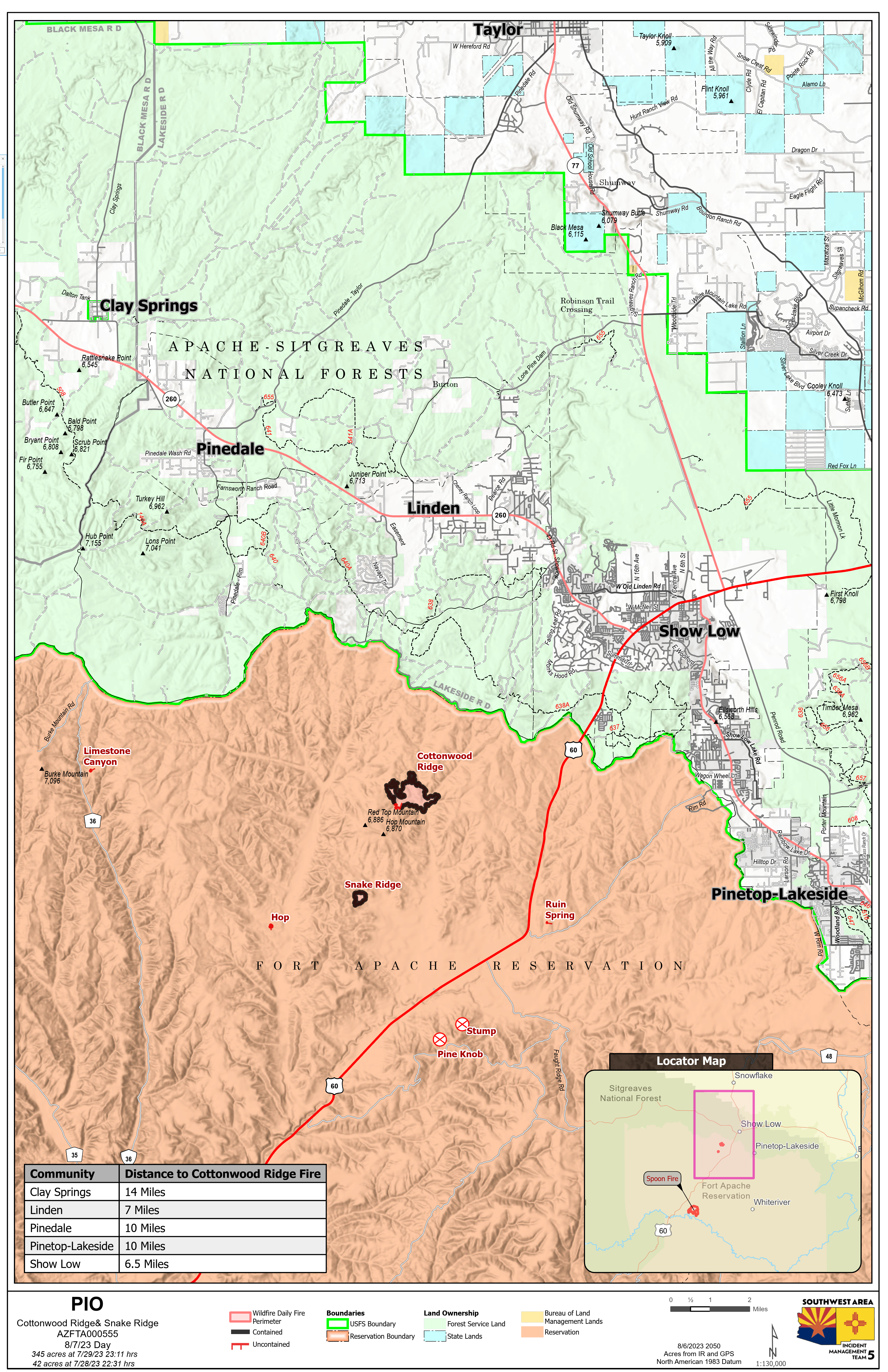
Cottonwood Ridge Fire Quick Facts

Acres: 345 Cause: Lightning Containment: 95% Start Date: July 23, 2023 Location: 4 miles south of Show Low, AZ Fuels: Timber, grass, brush

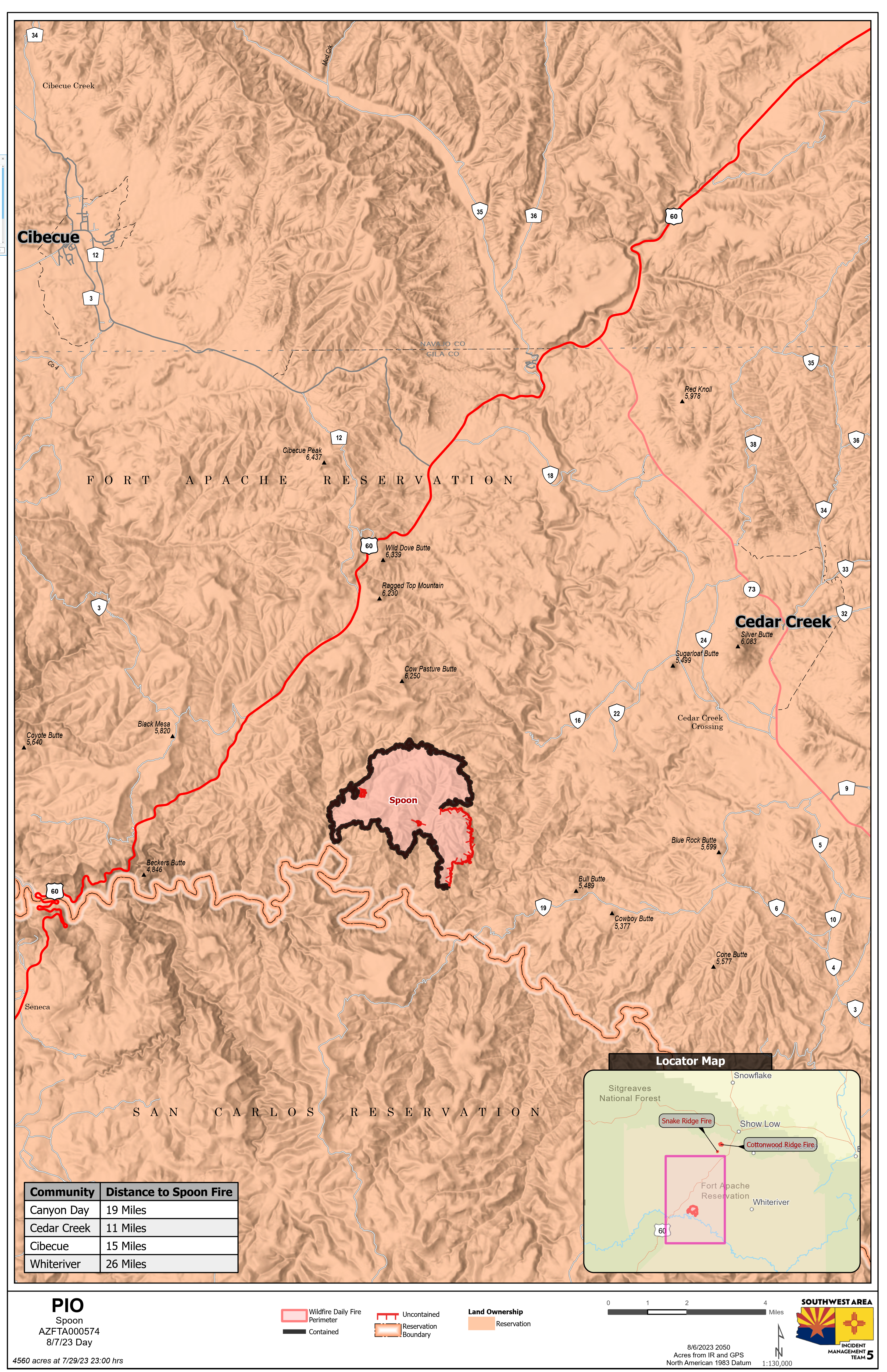
Spoon Fire Quick Facts Acres: 4,560 acres Cause: Lightning Containment: 80% Start Date: July 24, 2023 Location: 2.5 miles east of Highway 60 between Globe and Show Low, AZ. 11 miles southwest of Cedar Creek Fuels: Piñyon- Juniper, Manzanita, Grass, Cedar

Total personnel for all incidents: 232

Sunday, the weather remained hot and dry with winds gusts up to 20 mph. Crews continued to repair the containment lines by turning over dirt to make sure there were no hot spots near the fire’s edge. The Spoon Fire is 80% contained, and the Cottonwood Ridge fire remains at 95% contained. There were no new fires reported on Sunday. Crews continued mopping up the fire on Chediski Mountain. A hand crew and a dozer worked around the perimeter looking for hot spots and heat sources.

Cottonwood Ridge and Spoon fires: The excavators and hand crews continued repairing dozer lines and returning the land back to its natural state. On the Cottonwood Ridge fire crews are about 50% done with the repair process. Crews on the Spoon fire worked back up the hill from Carrizo Creek repairing the dozer line and have completed about 75 % of the work that needs to be completed.

Weather: The forecast for Monday calls for a 50% chance of thunderstorms and a possibility of new lighting strikes. Firefighters will remain prepared to respond to any new fire starts.

This will be the last update for Southwest Area Incident Management Team 5. The team will be turning management of these fires back to the Fort Apache Agency. The team would like to give a big thank you for allowing us to come into your community and we appreciate the warm welcome we received.

For More Information: For further updates regarding fires on the Fort Apache Reservation, please visit: Facebook: https://www.facebook.com/BIAFAAFireMgt/

More Information: For further updates regarding fires on the Fort Apache Reservation, please visit: Facebook: https://www.facebook.com/BIAFAAFireMgt/