 Location of Origin: Apache-Sitgreaves National Forests, Clifton Ranger District
Start Date: June 6, 2020
Size: Approximately 1,200 Acres
Cause: Lightning
Percent Contained: 0
Personnel: Approximately 155
Resources Assigned: 3 hotshot crews, 1 initial attack crew, 3 Type 6 engines, 1 Type 3 engine, 2 water tenders, 1 Type 1 helicopter, 1 Type 2 helicopter, 1 Type 3 helicopter, various incident management overhead.
Winds Push Bringham to the West and Increase Fire Size
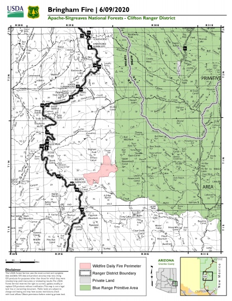
Driven by winds, the Bringham Fire continued to grow yesterday and is now at 1,200 acres. The cold front that moved in on Monday provided cooler temperatures and lower relative humidity, but it also created winds that pushed the fire towards the west. Helicopters of various types were utilized to target areas where there was increased fire activity.
Fire crews began work today on fuels prep for potential burnout operations to reinforce areas near Highway 191, a primary holding feature for future containment. Structure protection continued at the Rose Peak lookout fire-tower, and at various private properties in the vicinity of the fire. Firefighters also conducted recon missions to inform fire management planning, and they monitored critical areas of concern along fire lines.
Tentative burnout operations are being planned to reinforce holding features and could bring smoke and fire close to Highway 191. To ensure public safety, the highway has been closed in both directions for the next seven days. The closure is between mile-marker 186 and mile-marker 225. ADOT signage will be in place near both blockades on Highway 191. Only owners or lessees of land within the area will be exempted from the highway closure. ADOT issued a traffic advisory for Highway 191, and more information can be found at https://azdot.gov/adot-news/us-191-closed-eastern-arizona-mountains-due-bringham-fire.
The primary objective for the incident management team is firefighter and public safety, and forest visitors are reminded to use caution when traveling in the vicinity of the fire as smoke may reduce visibility, especially in the evenings as smoke settles in lower elevations. There is also a large amount of emergency vehicle traffic, so please proceed with caution while driving in the area.
Fire information can be found on InciWeb at https://inciweb.nwcg.gov/incident/6747/. Information about the Apache-Sitgreaves National Forests can be found at www.fs.usda.gov/asnf.

