Daily Update 6/24/2021
Announcement: Communities that were asked to evacuate were allowed to return to their homes at 6:00 am this morning. Please stay diligent and be aware of current fire conditions.
Overview: Clouds and light rain showers provided a welcome relief, slowing fire growth on both the Wyrick and West Chev fires. This will give firefighters an opportunity to build fireline directly next to the fire, taking advantage of this temporary reprieve to gain containment on the Wyrick Fire.
Fire Update: On Wednesday, the West Chev Fire remained active. Helicopters were used to keep the fire from moving to the south in the timber that lines the steep canyons. Firefighters are assessing how to safely construct fireline to contain the West Chev Fire. Firefighters were able to make progress on the Wyrick Fire, slowly building line by hand and dozers to contain the fire. Today, firefighters will patrol and douse hot spots on the southeast corner of the fire and Crews will also continue to work toward the rim of Black Canyon on the eastern edge of the Wyrick Fire to prevent movement to the south and east. Weather: Light showers on Wednesday provided a welcome relief, cautioning that one day of rain doesn’t erase the two-year rain deficit. There is a 20% chance of lightning, with the potential for gusty outflow winds. Winds will be out of the west/southwest today with gusts up to 25 mph. As the weather dries out and warms up the next few days, smoldering logs and trees will again begin to burn and winds could carry spots out in front of the main fire.
Ready, Set, Go: The Navajo County Sheriff’s Office announced that residents in GO status were allowed to return to their homes this morning. Visit Navajo County Emergency Management for additional information about the Ready, Set, Go program and how to sign up for alerts.
Areas in SET:
• Antelope Valley
• Despain Ranch
• Heber-and Overgaard
• Chevelon Retreat
• Communities south and east of State Route 277
• High Country Pines in Heber
• Kendall Ranch / Camp Ponderosa
Wyrick
Start Date: Saturday, June 19, 2021
Acres: Wyrick: 7,452 acres
Cause: Lightning
Location: 2 miles north of Mogollon HS, Heber, AZ
Containment: 15%
Fuels: Pinyon-Juniper, Timber and grass
Total Personnel: 288
West Chev
Start Date: Saturday, June 19, 2021
Acres: 400 acres
Cause: Lightning
Location: 12.5 miles northwest of Heber, AZ
West Chev: 0%
Fuels: Timber and grass
Areas in READY:
• Chevelon Ranches
Closures: The Apache-Sitgreaves National Forests have announced a forest closure starting Thursday morning at 6:00 am. Additional details can be found at Apache-Sitgreaves National Forests – News & Events (usda.gov). Forest Road 504 remains closed because fire crews are working to secure the Wyrick Fire. State Routes 260 and 377 have reopened heading into the Heber-Overgaard area, according to the Arizona Department of Transportation. Continue to watch AZ511.gov for the latest updates.
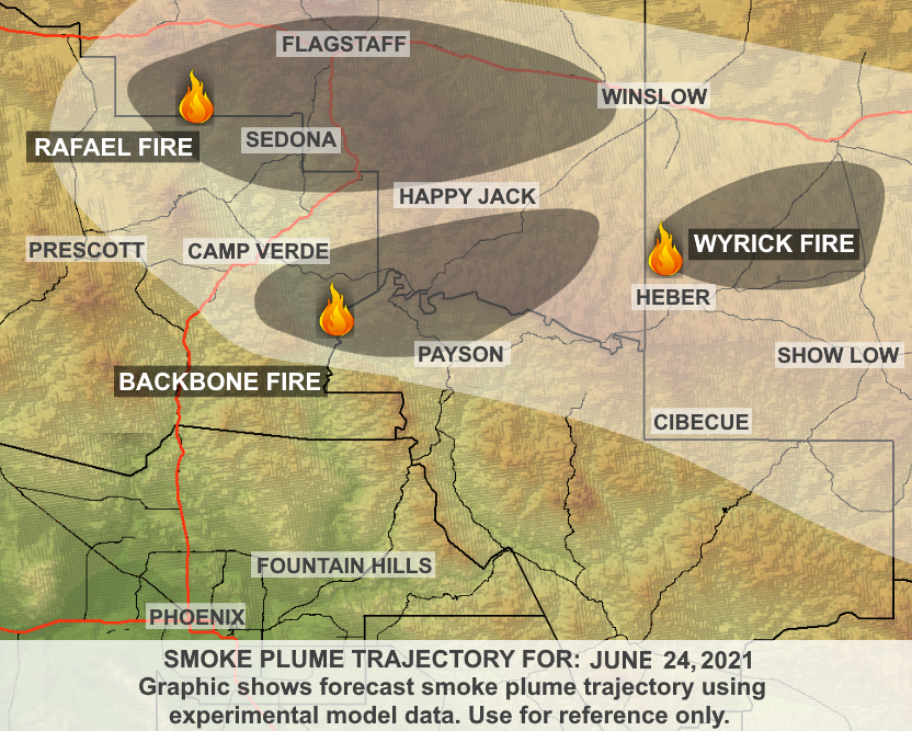
Smoke: Localized smoke impacts may exist in communities east of the fire if fire activity picks up, mainly in the afternoon. Expect smoke production from the east side of Wyrick this afternoon once conditions dry out, especially southern facing slopes in the fire perimeters. While not a lot of smoke is expected from both fires today, this weekend is trending drier and hotter, so expect some smoke production. A predominant southwest wind today should transport any generated smoke to the Northeast. If fire activity increases, expect smoke impacts to Holbrook, Snowflake, Concho, St. Johns, and Winslow. Overnight drainage winds may push smoke into Forest Lakes. Air quality today is moderate because of multiple fires in Arizona. The Daily Smoke Outlook can be found by visiting https://fires.airfire.org/outlooks/EasternArizona Values: Firefighter and public safety are the highest priorities on these fires. The fire areas include power lines and radio towers, private property, and natural resources. More Information:
Inciweb:
• West Chev: West Chev Information – InciWeb the Incident Information System (nwcg.gov)
• Wyrick: Wyrick Fire Information – InciWeb the Incident Information System (nwcg.gov)
Wyrick-West Chev Fire Information: (20+) Wyrick-West Chev Fire Information | Facebook
Apache-Sitgreaves National Forests: Apache-Sitgreaves National Forests – Home (usda.gov)
Eastern Arizona Current Outlook: Smoke Forecast Outlooks (airfire.org)
Highway Closures: https://az511.gov/
Navajo County Emergency Management: https://www.navajocountyaz.gov/Departments/Emergency-Management-and-Preparedness/Ready-Navajo-County-Notification-System/Ready-Navajo-County-Registration
Navajo County Emergency Management Facebook: https://www.facebook.com/NavajoCountyEM/
Navajo County Sheriff’s Office: https://www.facebook.com/NCSO.AZ/posts/4060988313951038
Wyrick Fire Update 6/24/2021
Reply