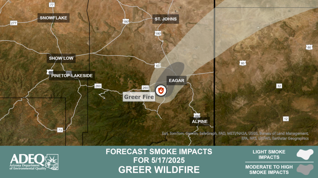
This morning, smoke has settled in the Eagar/Springerville area, with the heaviest impacts expected until 9 am.
Smoke is expected to disperse to the northeast throughout the afternoon with moderate impacts to Eagar/Springerville. Overnight smoke will settle into low-lying areas adjacent to the fire with light to moderate impacts to Eagar/Springerville, especially the western and southern side of Eagar.
Tomorrow, smoke will disperse to the east-northeast with moderate impacts to Eagar/Springerville.
Successful firing operations aid in securing the fire edge
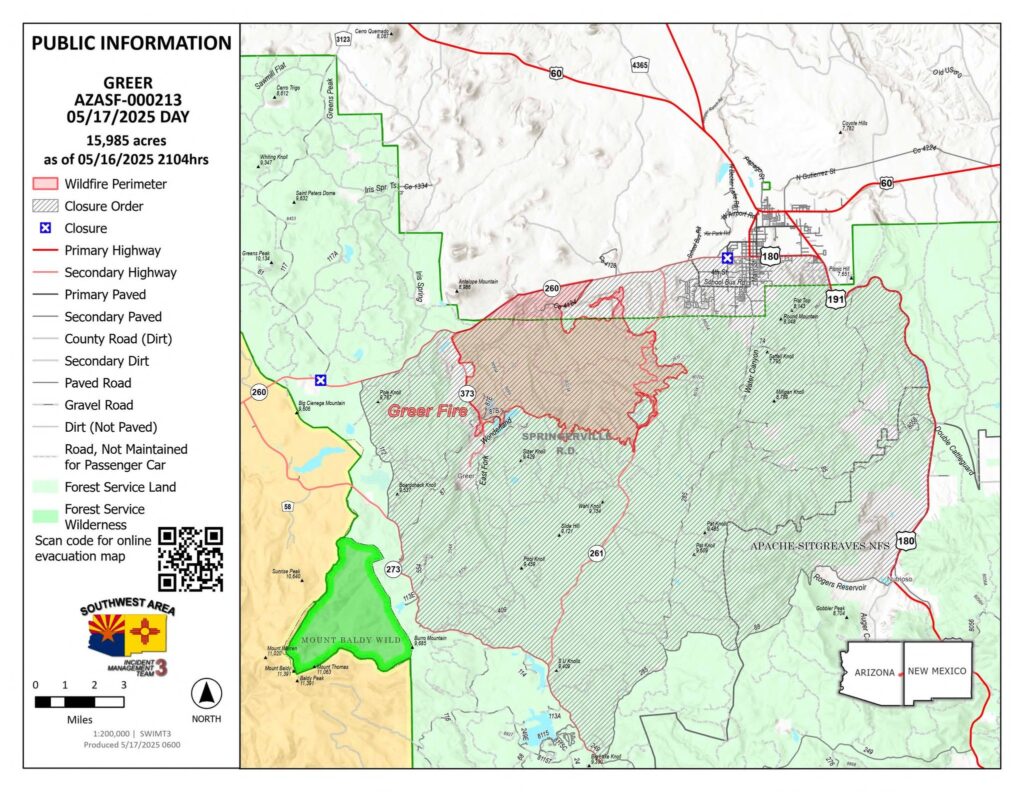
Acres: 15,985Start Date: May 13, 2025 Location: Greer, AZ
Cause: Under Investigation Personnel: Approximately 490 Fuels: Grass, Shrubs, Timber Containment: 0 percent
Highlights: Firefighters’ hard work over the past several days will be tested by higher winds today and tomorrow.
Operations: Control lines continued to hold near Greer as firefighters reinforced the fire’s western edge. Firing operations south of HWY 260 on the north end of the fire, as well as at the intersection of 260 and 261 along completed dozer lines, were successful in limiting the fire’s spread to the north and northeast yesterday. Aerial resources were active on the eastern edge of the fire, supporting ground crews by slowing growth. Yesterday evening, firefighters finished prepping along 261 working south and began firing operations, continuing their efforts throughout the night. Today, firefighters are working to secure all completed holding lines, while aircraft continue to assist with water drops as weather conditions allow. Due to inaccessible terrain and limited holding features on the southern edge of the fire, firefighters are using aircraft to limit spread and scout for potential areas to hold the fire and tie in existing lines.
Operational updates will be posted to the incidents Facebook page mid-morning daily for more detailed tactics and operational plans.
Weather: Fire personnel are preparing for a red flag warning issued for this morning with critical fire weather today and tomorrow, as stronger winds with gusts to 35 and lower humidities are forecast.
Closures: The Apache-Sitgreaves National Forest has issued a closure order for parts of the National Forest lands. Stage 2 Fire Restrictions are also in effect, prohibiting fire, campfire, or stove fire, including charcoal and briquettes and smoking.
Evacuations: The Apache County Sheriff’s Office has issued multiple evacuation orders. GO: Greer, South Fork, and residents west of Highway 261. Eagar, south of HWY 260 and West of River Road SET: All Eagar residents south of State Route 260 and between River Road and the SR260/180 junction. All residents south of SR 260, north of Forest Service Rd 85, and between Water Canyon Rd and US-191/180 and all residents north of SR 260 and west of Burk Rd, this includes residents in Springerville, AZ that are west of US-191. There is an interactive evacuation map linked below in the QR code link tree.
Shelter for evacuees are open at the County Fairgrounds in St. Johns and the Alpine Community Center.
Highway 260 is closed in both directions near Greer. For updated travel information: az511.comSafety: A temporary flight restriction has been issued over the fire area. It is illegal to fly drones within the area.
Firing operations on the north end of the fire have been successful throughout the day and will continue overnight. Fire spread east of Highway 261 has remained minimal, as firefighters hold the line with support from aerial water drops. Fire has not spread north of 260 and has held because of the firing operations. On the west side near Greer, containment lines are holding well, and crews are working to cool remaining hot spots. Some fire activity continues on the southern edge, where aerial resources are being used to cool the area while firefighters prepare additional containment lines further south, away from the fire’s edge.
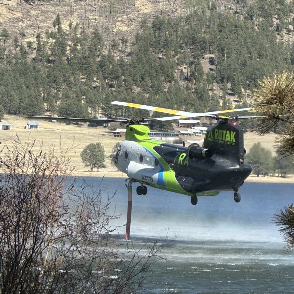
Photo: Type 1 helicopter filling water from Greer Lakes today to support ground crews’ efforts.