Firefighters increase containment as hot and dry weather continues
Daily Update 6/26/2021
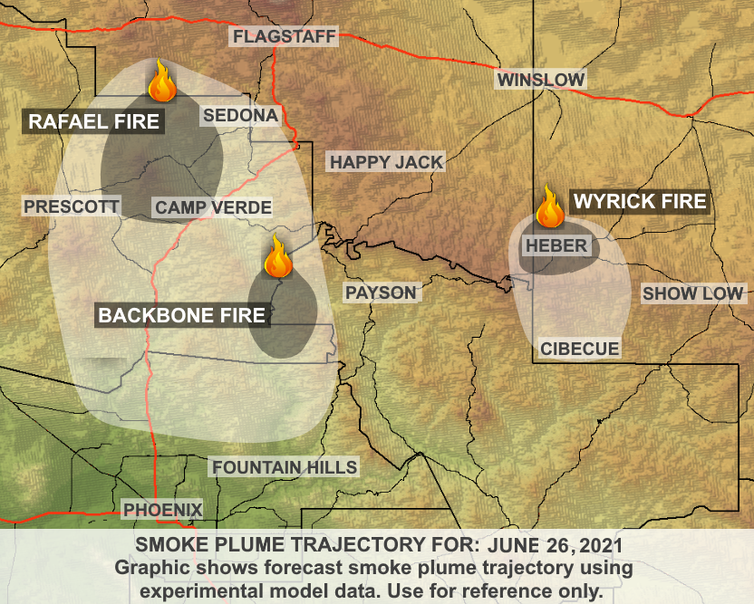
Wyrick
Start Date: Saturday, June 19, 2021
Acres: Wyrick: 7,592 acres
Cause: Lightning
Location: 2 miles north of Mogollon HS, Heber, AZ
Containment: 42%
Fuels: Pinyon-Juniper, Timber and grass
Total Personnel: 350
West Chev
Start Date: Saturday, June 19, 2021
Acres: 1,036 acres
Cause: Lightning
Location: 12.5 miles northwest of Heber, AZ
West Chev: 28%
Fuels: Timber and grass
Announcement: Forest Road 504 is open to residents and property owners. Drivers are asked to drive slowly and remain alert for increased fire-related traffic on this route.
Overview: Imagery from an IR (infrared) flight overnight shows isolated pockets of heat on the two fires, and some increase in the size of the West Chev Fire. Fire behavior yesterday was moderate.
Heat sources remain along portions of the perimeters of both fires but continue to decline. Drought stressed trees and brush can accelerate the return of active fire behavior quickly. Today, firefighters will aggressively attack any flare-ups close to containment lines. Helicopters and air tankers are available to support ground resources.
Fire Update:
Wyrick: On Friday, hand crews and engines monitored, patrolled and improved containment lines around the fire perimeter, and mopped-up hotspots near containment lines. This work will continue today with firefighters mopping up farther into the fire where possible.
West Chev: Yesterday, firefighters constructed more fireline and conducted firing operations to remove fuel between the fire and containment lines. The West Chev Fire has been burning along the ground through pine needles, and firefighters fired out to 169B to secure the northwest flank. Today’s focus will be looking for opportunities to connect fireline across Circle Bar Draw, strengthen completed containment lines, and mop up hot spots that are close to fire’s edge.
Weather: Weather conditions will be warm and dry again today, with increased atmospheric instability and a greater chance of isolated afternoon thunderstorms and rain, which could lead to pushing embers in multiple directions. Morning winds are expected to be from the west and northwest. This afternoon they will be from the north. Today’s maximum temperature will be in the low 80s, with relative humidity ranging from 17 to 19%.
Ready, Set, Go: There have been no changes to yesterday’s direction.
Areas in SET:
• Antelope Valley
• Despain Ranch
• Heber-and Overgaard
• Chevelon Retreat
• Areas north of State Route 260 and northwest of State Route 277
Residents are asked to remain alert and keep apprised of current fire conditions.
Please visit Navajo County Emergency Management for additional information about the Ready, Set, Go program and how to sign up for alerts.
Closures: A complete closure of the Apache-Sitgreaves National Forests remains in effect. Additional details can be found at Apache-Sitgreaves National Forests – News & Events (usda.gov). Arizona State Trust Lands in all 15 counties are closed for recreational use. For current information on state routes, please continue to watch Arizona Department of Transportation’s AZ511.gov website.
Smoke: Localized smoke impacts may exist in communities east of the fire if fire activity picks up, mainly in the afternoon. Expect smoke production from the east side of Wyrick this afternoon once conditions dry out, especially southern facing slopes in the fire perimeters. While not a lot of smoke is expected from both fires today, this weekend is trending drier and hotter, so expect some smoke production. A predominant southwest wind today should transport any generated smoke to the northeast. If fire activity increases, expect smoke impacts to Holbert, Snowflake, Concho, St. Johns, and Winslow. Overnight drainage winds may push smoke into Forest Lakes. The area may see influence from the Backbone and Rafael fires if winds shift as predicted, from the north. The Daily Smoke Outlook can be found by visiting: https://fires.airfire.org/outlooks/EasternArizona
Values: Firefighter and public safety are the highest priorities on these fires. Additional values at risk include properties and infrastructure, as well as power and transmission lines, communication towers, campgrounds, critical range infrastructure, and cultural and natural resources.
More Information:
Inciweb:
• West Chev: West Chev Information – InciWeb the Incident Information System (nwcg.gov)
• Wyrick: Wyrick Fire Information – InciWeb the Incident Information System (nwcg.gov)
Wyrick-West Chev Fire Information: (20+) Wyrick-West Chev Fire Information | Facebook
Apache-Sitgreaves National Forests: Apache-Sitgreaves National Forests – Home (usda.gov)
Eastern Arizona Current Outlook: Smoke Forecast Outlooks (airfire.org)
Highway Closures: https://az511.gov/
Navajo County Emergency Management: https://www.navajocountyaz.gov/…/Ready-Navajo-County…
Navajo County Emergency Management Facebook: https://www.facebook.com/NavajoCountyEM/
Navajo County Sheriff’s Office: https://www.facebook.com/NCSO.AZ/posts/4060988313951038
Fire Restrictions in Arizona: WildlandFire.AZ.gov/fire-restrictions