A Red Flag Warning has been issued for much of northern Arizona today, therefore there is NO burning. Gusty winds, dry fuels, and low humidity will lead to easier fire starts and the potential for rapid spread. Please do your part!!
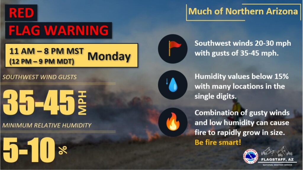

A Red Flag Warning has been issued for much of northern Arizona today, therefore there is NO burning. Gusty winds, dry fuels, and low humidity will lead to easier fire starts and the potential for rapid spread. Please do your part!!
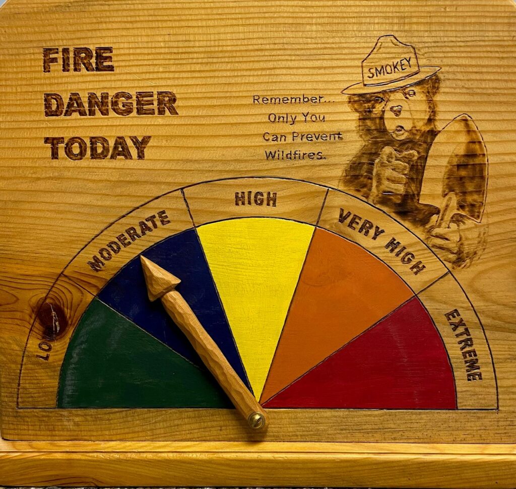
How do Fire Professionals decide Fire Danger?
Springerville, AZ, June 5, 2023 — Visitors to the National Forests notice the “Fire Danger Smokey Bear” signage found on the Forest. These signs indicate fire danger and have an arrow that points to one of five different ratings that range from Low to Extreme fire danger. But how do fire professionals decide?
A primary measure includes the Energy Release Component (ERC) which is a number related to the available energy (BTU) per unit area in front of a fire, or otherwise stated “how hot” is the fire burning. As live fuels cure and dead fuels dry, the ERC will increase and can be described as a build-up index, as it shows an annual progression.
The ERC is utilized by fire managers to analyze current fire danger in comparison with historical average and high fire danger years. The ERC is reported as a percentile, with the 90th percentile being a typical benchmark for high to very high fire danger, and the 97th percentile correlating to extreme fire danger.
Fire professionals use the ERCs and correlate them to the ratings and different colors on the fire danger Smokey Bear signs.
Low (L) fire danger indicates very little danger of fire, is usually in cool &/or wet conditions, and a dark green on the indicator wheel.
Moderate (M) ratings are seen when fire may start but they are unlikely to become serious and control is relatively easy for firefighters. Moderate is seen as either light green or blue on the indicator wheel.
High (H) ratings mean that fine, dead fuels ignite easily from most causes. Fires may become serious and control may be difficult unless they firefighters and attack successfully while the fire is small. High is seen as yellow on the indicator wheel.
Very High, (VH) means that fires start easily from all causes, spread rapidly and quickly increase in intensity, and may develop fire whirlwinds in heavier fuels. Very High is seen as bright orange on the wheel.
Extreme (E) means that fires start quickly, spread furiously and burn with high intensity. Fires quickly become unmanageable, fast moving and pose serious danger to any structure, persons or items in its path. Firefighting is difficult and control actions are only safely effective on the flanks of the fire until the weather changes or the fuel supply lessens. Extreme is a very bright red on the wheel.
Currently four Ranger Districts, including Alpine, Springerville, Lakeside and Black Mesa are at Moderate fire danger levels. The most southern portion of the Forest, the Clifton Ranger District is in High fire danger. The A-S has enjoyed a non-typical cool and wet spring, leaving fire managers several opportunities to implement prescribed fire or allow natural ignition to play a role in clearing hazardous fuels across the forest during these favorable conditions.
Fire managers will continue seeking opportunities to use prescribed fire or natural ignition, such as lightning to reduce hazardous fuels across the National Forests. As always, please feel free to contact local Forest Service offices at any time and for any questions.
Please follow us on Twitter @A_SNFs, on facebook.com/apachesitgreavesnfs, and on our website, https://www.fs.usda.gov/asnf.
Apache-Sitgreaves, Alpine Ranger District plans pile burning
Springerville, AZ, April 21, 2023 — The Apache-Sitgreaves National Forests is currently working to begin District wide prescribed fire pile burning on the Alpine Ranger District, beginning 4/26/2023 and continuing until April 30, 2023. The following prescribed fires will be initiated if conditions and approvals allow:
Our land management strategy is centered on long-term forest health, including reducing forest fuels and using prescribed fire on the landscape. Prescribed fires provide habitat diversity, recycle plant nutrients into the soil, and encourage new growth for various plants used by wildlife and livestock. They also reduce forest surface fuels which lessen the threat of large-scale wildfire impacts on private lands and communities.
Smoke will be a consideration in the vicinity of the prescribed fires depending on the weather and caution should be used when traveling in the area. Information on air quality and active prescribed fires can be found on Arizona Department of Environmental Quality’s webpage: https://azdeq.gov/.
Stay up to date on news from the A-S at our website https://www.fs.usda.gov/asnf, on Twitter @A_SNFs and on facebook.com/apachesitgreavesnfs.