WHITE MOUNTAIN ZONE TYPE 3 INCIDENT MANAGEMENT TEAM
Chris Johnson, Incident Commander
Gentry Fire Daily Update 7/03/2017
Discovered: June 28, 2017
Location: 12 miles southwest of Heber, AZ and 4 miles southeast of Forest Lakes, AZ near Black Canyon Lake on the Black Mesa Ranger District, Apache-Sitgreaves National Forests
Start Date: June 28, 2017 Percent contained: 60%
Size: 641 acres Cause: Lightning
Vegetation: Dead and down, ponderosa pine and brush
Personnel Assigned: 187 including 2 hotshot crews, 3 hand-crews, 1 bulldozers, 2 water tenders, 1 type 3 Helicopter, 2 engines
Update: Sunday (7/2/2017) high winds and dry conditions had crews focused on holding, monitoring, and deepening control lines around the fire. Rehab of interior dozer lines and chipping and scattering of slash along Forest Road 300 was completed.
Today crews will continue with rehab, focusing on trails and roads within the fire area in preparation of reopening roads and campgrounds to the public. Management of the fire is expected to be returned to the forest at 0600 Tuesday, July 4, 2017.
Weather: Lighter winds are expected today as high pressure builds over Arizona bringing a warming trend to the region. A slight chance of high based thunderstorms remains over the Mogollon Rim through today.
Recreation: The following closures remain in effect on the Black Mesa Ranger District: (Forest Order 01-17-601):
• Forest Road 300 south from Forest Road 86 to 487
• Brookbank Dispersed Camp area
• Forest Road 86 from Forest Road 300 to Baca Meadow including dispersed camp areas near Black Canyon Lake
• Black Canyon Lake Recreation Area
• Black Canyon Rim and Gentry Campgrounds
• Hangman Trail
The Apache-Sitgreaves remains in Stage 1 fire restrictions. No fires, no charcoal, and no smoking outside of developed (fee for use) campgrounds.
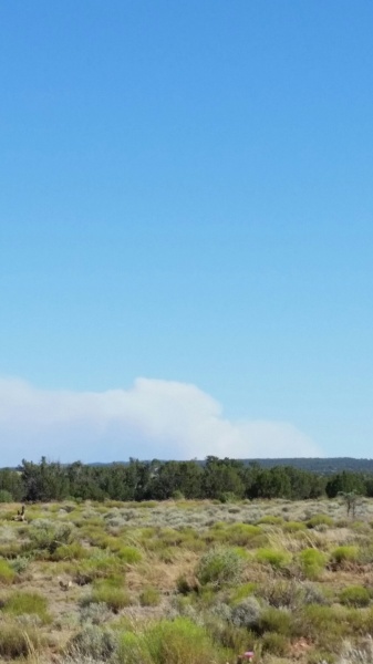
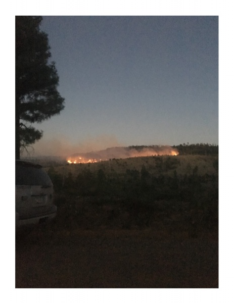
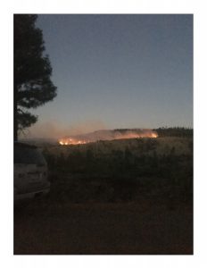
Community: While smoke may still be visible rising from the interior of the fire the impact to local communities from the Gentry Fire will be minimal.
Overview: The fire was reported Wednesday afternoon June 28, 2017. Initial attack on the fire was hindered by rugged terrain and heavy dead and down fuels within the 2002 Rodeo-Chediski Fire scar.
Fire Information: Gentry Fire Information: (928) 535-7300
Information Office Hours: 8 a.m. to 4:30 p.m. Monday through Friday, Closed Tuesday 7/4 for Independence Day
InciWeb: https://inciweb.nwcg.gov/incident/5300/
Web: www.fs.usda.gov/asnf
Facebook: https://www.facebook.com/apachesitgreavesnfs
Twitter: @A_SNFs
Email: dlroznovak@fs.fed.us
Update: Fire crews made excellent progress on the fire yesterday (6/30/2017). Utilizing dozer lines, hand lines, existing roads, and burn-out operations, fire crews were able to complete and reinforce a control line around the entire fire perimeter. Friday evening crews continued to reinforce the control lines with burn out operations. The term “burn out” refers to introducing fire inside a control line to consume flammable fuels located between the edge of the main fire and the control line.
Today’s operations will focus on holding, monitoring, and mop-up, removing or extinguishing remaining flammable material along or near the control line.
Weather: Winds are expected to increase today to 10-15 miles per hour out of the southwest. Sunny skies and higher than normal temperatures will continue through the weekend.
Recreation: The following closures remain in effect on the Black Mesa Ranger District: (Forest Order 01-17-601):
• Forest Road 300 south from Forest Road 86 to 487 (near Turkey Springs)
• Brookbank Dispersed Camp area
• Forest Road 86 from Forest Road 300 to Baca Meadow including dispersed camp areas near Black Canyon Lake
• Black Canyon Lake Recreation Area
• Black Canyon Rim Campground
• Gentry Campground
• Hangman Trail
The Apache-Sitgreaves remains in Stage 1 fire restrictions. No fires, no charcoal, and no smoking outside of developed (fee for use) campgrounds.
Community: Smoke is expected to impact Heber-Overgaard and State Route 260 through the weekend and may be heavy at times. The fire is not a direct threat to the community and will not impact the holiday activities planned by the Heber Overgaard Chamber of Commerce.

Gentry Fire Information: (928) 535-7300
Information Office Hours: 8 a.m. to 4:30 p.m. Monday through Friday, Closed Tuesday 7/4 for Independence Day
Web: www.fs.usda.gov/asnf
Facebook: https://www.facebook.com/apachesitgreavesnfs
Twitter: @A_SNFs
Gentry Fire
Discovered: June 28, 2017
Location: 12 miles southwest of Heber, AZ and 4 miles southeast of Forest Lakes in Gentry Canyon on the Black Mesa Ranger District of the Apache-Sitgreaves National Forests
Start Date: June 28, 2017 Percent contained: 0%
Size: Approximately 175 acres Cause: Lightning
Vegetation: Ponderosa pine and brush with heavy dead and down component
Personnel Assigned: 165 including 2 hotshot crews, 5 Hand-crews, 2 Bulldozers, 3 water tenders, 1 type 1 helicopter, 1 type 3 helicopter, 2 engines
Update: Last night (6/29/2017) fire crews were began critical burn out operation to enforcing the dozer line to the east. Fire activity was moderate with some spotting along the line. Crews were able to contain the spots and continued to hold and reinforce line.
Today’s operations will focus on holding and monitoring the lines. Weather conditions permitting, crews hope to introduce fire to reinforce the lines and to remove unburned fuels within the fire area.
Weather: Light winds are expected throughout the day with sunny skies and higher than normal temperatures remaining over the region through the weekend.
Recreation: The following closures remain in effect on the Black Mesa Ranger District: (Forest Order 01-17-601):
• Forest Road 300 south from Forest Road 86 to 487 (near Turkey Springs)
• Brookbank Dispersed Camp area
• Forest Road 86 from Forest Road 300 to Baca Meadow including dispersed camp areas near Black Canyon Lake
• Black Canyon Lake Recreation Area
• Black Canyon Rim Campground
• Gentry Campground
• Hangman Trail
Community: Smoke is expected to impact Heber-Overgaard and State Route 260 through the weekend and may be heavy at times. The fire is not a direct threat to the community and will not impact the holiday activities planned by the Heber Overgaard Chamber of Commerce.
Overview: The fire was reported Wednesday afternoon and was estimated to be at 2 acres. Direct attack on the fire proved challenging due to the rugged terrain and heavy dead and down component within the 2002 Rodeo Chediski Fire scar therefore, an indirect suppression tactic is being employed. Crews are utilizing existing roads and new dozer lines to keep the fire footprint as small as possible.
Structures Threatened: Gentry Fire Tower and Gentry Campground
Fire Information: The Apache-Sitgreaves remains in Stage 1 fire restrictions. No fires, no charcoal, and no smoking outside of developed (fee for use) campgrounds.
Know Before You Go:
o Northeastern Arizona Public Information System: https://311info.net/ or call 311 or 928.333.3412
o Arizona Fire Restrictions: http://firerestrictions.us/az/
o Fire Restrictions and Red Flag Alerts: http://wildlandfire.az.gov/
o Wildfires Near Me: http://www.wildfiresnearme.wfmrda.com/
Gentry Fire
June 29, 2017 11:00 a.m.
Location:
• Black Mesa Ranger District of the Apache-Sitgreaves National Forests
• Navajo County, Arizona
• 5 miles southeast of Forest Lakes, 10 miles southwest of Heber/Overgaard.
Start Date: 6/28/2017 Percent Contained: 0
Size: 100 acres Resources Assigned: 50 – 60 personnel
Cause: Lightning Growth Potential: Moderate
Vegetation: Dead and down (the old Structures Threatened: Gentry Lookout
Rodeo/Chediski burn area) and brush
Summary: Transitioning to White Mountain Zone Type 3 Team at 2:00 p.m. today, Incident Commander will be Matt Bullmore. Fire managers plan to employ a suppression strategy on the fire. Crews are performing structure protection around the Gentry Lookout today. They have hand line to the west of the fire, dozer line to the east, FR 300 is being used as the holding line to the south, and FR 86 to the north. Potential for growth on the east side of the fire, west side is holding well. If conditions allow there will be an approximate burn out of 400 acres this evening. It is anticipated that the Gentry Fire will help clean up much of the dead and down material left by the Rodeo/Chediski Fire, thereby reducing the future probability of high-intensity wildfire and its potentially severe and negative fire effects.
A closure order is currently being established for the fire area. Details regarding the closure area will be provided as soon as they are available. FR 86 and possibly sections of FR 300 will be closed to ensure public safety and allow fire fighters to effectually suppress the fire.
Additional information sources, including maps, will be provided as soon as they are available.
Know Before You Go:
o Northeastern Arizona Public Information System: https://311info.net/ or call 311 or 928.333.3412
o Arizona Fire Restrictions: http://firerestrictions.us/az/
o Fire Restrictions and Red Flag Alerts: http://wildlandfire.az.gov/
o Wildfires Near Me: http://www.wildfiresnearme.wfmrda.com/
 6/29/17 8:43 am
The Gentry Fire is currently 80 acres and is located in Navajo County north of Black Canyon Lake. No structures are currently threatened. A Black Mesa District Type 3 Fire team will be working the Gentry Fire through the 4th of July weekend. This fire is located just south of Gentry Lookout and north of Black Canyon Lake, between Forest Roads (FR) 300 and 86. We expect 150 firefighters working on the fire. The fire is expected to grow to 400 acres after burnout operation. The fire will disrupt camping and recreation use in this area for the 4th of July weekend.
To secure public and firefighter safety, access to the area will be closed during the fire. Road closures will occur at (FR) 86 road at Baca Meadows and at Forest road 300/86 junction. The 300 South road will also be closed at the 300/86 road junction and at the 487/300 junction to the east. Public access to Black Canyon Lake will also be closed. More information will follow soon.