Rattlesnake Fire Update for Monday 4/16/18

Southwest Area
Incident Management Team
Team 5 – Jeff Andrews – Incident Commander
Media & Public Information Contact:
Email: rattlesnakefireinfo2018@gmail.com
Phone: (928) 205-5662
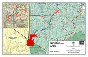
Rattlesnake Fire
Firefighters watching weather predictions
Location: Southeast of Whiteriver, AZ
Cause: Human Caused-under investigation
Percent containment: 3%
Start date: Wednesday, April 11, 2018
Size: 5,719 acres (1600 Sunday night)
Vegetation: Ponderosa pine and grass understory
Resources: Approximately 260 personnel
Location: The Rattlesnake Fire continues to burn southeast of Whiteriver, Arizona, on the Fort Apache and San Carlos Apache Indian Reservations and the Apache-Sitgreaves National Forests. Southwest Area Incident Management Team 5 is now managing the Rattlesnake Fire.

A Red Flag Warning has been issued for Northern Arizona from 11:00 am to 11:00 pm Monday. The warning was issued for high winds, low humidity and high fire danger. A second storm will bring increasing winds later in the week. These two storms may limit the ability to utilize air tankers and helicopters, and cause dead standing snags to fall over which is a safety concern for firefighters working in the area. The amount of moisture in the grasses and logs are at record lows. These conditions are historically seen during June, causing fire managers to carefully assess where to place fire crews as the storms pass through the area. Crews have been working to secure line up through the Black River corridor, building a “catchers mitt” of containment line along Forest Road 25I. Firefighting resources are also being mobilized to the southeast side of the fire, where they will begin improving fire lines used during the Wallow Fire.

Closures: The closure order on the Alpine Ranger District of the Apache-Sitgreaves National Forest has been expanded to include all of the Bear Wallow Wilderness and areas south and west of Forest Road 25. Several roads on the Fort Apache Indian Reservation within the boundary of the Rattlesnake Fire will be closed: The Y79 road at the Y40 Junction and the 25F road at the Y40 junction. Please drive carefully and turn on headlights if traveling on the Y40 road.

Restrictions: Modified Stage 2 Fire Restrictions continue on the Fort Apache Indian Reservation. Campfires will NOT be allowed during the hours of 7:00 a.m. to 7:00 p.m. and debris burning is prohibited until further notice.

Anyone having information regarding how the Rattlesnake Fire started is asked to contact WE-TIP at 1-800-47ARSON (1- 800-472-7766).

InciWeb page (https://inciweb.nwcg.gov/incident/5740)
BIA Fort Apache Facebook page (https://www.facebook.com/BIAFAAFireMgt/)
Apache-Sitgreaves National Forests Facebook page (https://www.facebook.com/apachesitgreavesnfs)
Apache-Sitgreaves National Forests Twitter page (https://twitter.com/A_SNFs)
Northern Arizona Public Information System (www.311info.net)

Nowhi ni’ nłt’eego anłsih – Take care of our land

Rattlesnake Fire Update for Friday April 13

Location: Southeast of Whiteriver
Start date: Wednesday, April 11, 2018
Cause: Unknown/Under investigation
Vegetation: Ponderosa pine and grass understory
Size: Approximately 760 acres (Fort Apache Indian Reservation: 600 acres, Apache-Sitgreaves NF/ San Carlos Indian Reservation: 160 acres)
Resources Assigned: Approximately 158 personnel
Percent Containment: 0%

Firefighters are still working to contain the Rattlesnake fire and strategy for the incident is full suppression. Yesterday, strong winds made containment progress slow. Fire crews completed control lines in the southwest section of the fire, securing it off of Rattlesnake point. Aircraft was grounded due to high winds. A spot fire was established on San Carlos Agency side of Black River in an isolated area.

Today, Crews will continue to prepare control lines along the north flank of the fire. Firefighters will construct indirect lines in the western flank of the fire. The high winds will continue to hamper containment progress.

A Red Flag warning is in effect from noon to 9:00 pm this evening. Today the winds will shift and will be coming from the north and northwest and pushing the fire in a south and southwesterly direction.

Several roads within the boundary of the Rattlesnake Fire will be closed: The Y79 road at the Y40 Junction and the 25F road at the Y40 junction. The public is asked to drive carefully and turn on their headlights if traveling on the Y40 road.

Modified Stage 2 Fire Restrictions are in effect on the Fort Apache Indian Reservation. Campfires will NOT be allowed during the hours of 7:00 a.m. to 7:00 p.m. and debris burning will be prohibited until further notice.

Anyone having information regarding the Rattlesnake Fire contact WE-TIP at 1-800-47ARSON (1-800-472-7766). Official incident information will be posted online at the Rattlesnake Fire InciWeb page (https://inciweb.nwcg.gov/incident/5740) and BIA Fort Apache Facebook page (https://www.facebook.com/BIAFAAFireMgt/).

Prescribe Burn on White Mountain Apache Tribe

4/2/18 – The Tribal Forestry Department will be coordinating a prescribe burn with White Mountain Apache Fire and Rescue Department and Pinetop Fire Fuels Reduction crew.  The prescribe burn will reduce the amount of ground fuel around the Hon-Dah Resort Casino and Conference Center.

The prescribe burn will take place on April 3, 2018. The prescribe burn will be based on favorable weather conditions which include but not limited to the current weather forecast, air quality and fuel moisture.  The prescribe fire will help to reduce ground fuels and help protect property for the  Hon-Dah Resort Casino and Conference Center. See attached map for the location of the prescribe burn area.

Nearby residents should expect smoke inthe area and drivers should pay extra attention while traveling through the area of the prescribe burn. Individuals with respiratory problems are advised to avoid the outdoors as much as possible. The public will not be allowed in the prescribe fire burning area.

If you have any questions please feel free to contact Logan Lawson at the Tribal Forestry Department (928)338-1665 or (928)594-6415.