 Fort Apache Agency continues to conduct prescribed burning on the Fort Apache Indian Reservation. Since October 9, 2019, a total of 14,868 acres has been treated within several burn units. Broadcast burning treatments will be conducted in several burn units until November 23, 2019 upon favorable conditions. Pile burning treatments will begin after November 23, 2019 within the Rodeo-Chediski Burned area.
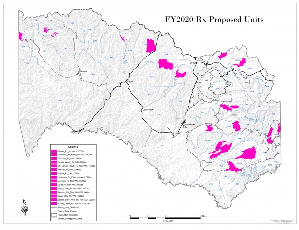
This week prescribed burn resources are planning to treat burn blocks within the following prescribed burn units:
Turkey Burn Unit (10 miles east of Whiteriver): Prescribed burn efforts will continue over the next two days.
Hondah burn unit (3 miles east of McNary): Resources will continue to treat the remainder of the burn blocks within this burn unit today and tomorrow.
Soldier burn unit (8 miles east of McNary): Resources will begin treatment efforts on Wednesday, November 6, 2019.
Sevenmile burn unit (8 miles east of Whiteriver): Resources will resume prescribed burn efforts within this burn unit on Wednesday, November 6, 2019.
Maverick burn unit (25 miles east of Whiteriver): Resources will resume prescribed burn efforts within this burn unit on Wednesday, November 6, 2019.
Nearby residents should expect smoke in the vicinity and drivers should pay extra attention while traveling through or adjacent to burn areas. All Prescribed Fire activity will be carefully monitored and will comply with smoke management guidelines to reduce the impact of smoke on local residents. If conditions become unfavorable, prescribed burning efforts will be ceased to mitigate smoke impacts to the communities.
The next update will be on Monday, November 11, 2019. The public should avoid entering the burn units for their safety and fire fighter safety. If you have any questions regarding our upcoming prescribed burning efforts, you can call Candy Lupe, Public Information Officer at (928) 338-5425, (928) 205-5662 or you can log onto BIA Fort Apache Agency’s Facebook page, https://www.facebook.com/BIAFAAFireMgt.


 11/4/19 10:30 – Navajo County Sheriff’s Office is attempting to locate 3 individuals involved in an attempt to pass counterfeit money earlier tonight at the Dollar General store in Overgaard. The suspects threatened the clerk and then ran when deputies arrived. Subjects should be considered armed and dangerous! DO NOT APPROACH.