Bringham Fire, June 9, 2020

Location of Origin: Apache-Sitgreaves National Forests, Clifton Ranger District
Start Date: June 6, 2020
Size: Approximately 1,200 Acres
Cause: Lightning
Percent Contained: 0
Personnel: Approximately 155
Resources Assigned: 3 hotshot crews, 1 initial attack crew, 3 Type 6 engines, 1 Type 3 engine, 2 water tenders, 1 Type 1 helicopter, 1 Type 2 helicopter, 1 Type 3 helicopter, various incident management overhead.

Winds Push Bringham to the West and Increase Fire Size

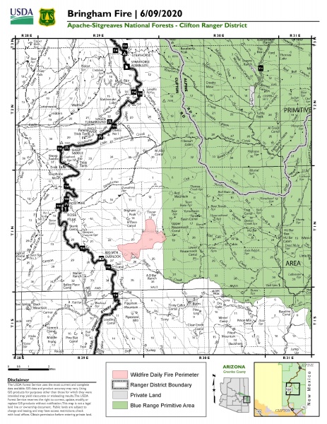
Driven by winds, the Bringham Fire continued to grow yesterday and is now at 1,200 acres. The cold front that moved in on Monday provided cooler temperatures and lower relative humidity, but it also created winds that pushed the fire towards the west. Helicopters of various types were utilized to target areas where there was increased fire activity.

Fire crews began work today on fuels prep for potential burnout operations to reinforce areas near Highway 191, a primary holding feature for future containment. Structure protection continued at the Rose Peak lookout fire-tower, and at various private properties in the vicinity of the fire. Firefighters also conducted recon missions to inform fire management planning, and they monitored critical areas of concern along fire lines.

Tentative burnout operations are being planned to reinforce holding features and could bring smoke and fire close to Highway 191. To ensure public safety, the highway has been closed in both directions for the next seven days. The closure is between mile-marker 186 and mile-marker 225. ADOT signage will be in place near both blockades on Highway 191. Only owners or lessees of land within the area will be exempted from the highway closure. ADOT issued a traffic advisory for Highway 191, and more information can be found at https://azdot.gov/adot-news/us-191-closed-eastern-arizona-mountains-due-bringham-fire.

The primary objective for the incident management team is firefighter and public safety, and forest visitors are reminded to use caution when traveling in the vicinity of the fire as smoke may reduce visibility, especially in the evenings as smoke settles in lower elevations. There is also a large amount of emergency vehicle traffic, so please proceed with caution while driving in the area.

Fire information can be found on InciWeb at https://inciweb.nwcg.gov/incident/6747/. Information about the Apache-Sitgreaves National Forests can be found at www.fs.usda.gov/asnf.

ADOT Pavement preservation project on the US 60 between 40th Street and State Route 61 starts April 27 in the White Mountains

Expect traffic restrictions, possible delays during the nearly six-month project

Drivers in the White Mountains area should plan for traffic restrictions and possible delays beginning Monday, April 27, as the Arizona Department of Transportation starts a new $4.6 million pavement preservation project on the US 60.

ADOT crews will remove the existing pavement and replace it with new asphalt along 9 miles of US 60 between 40th Street and State Route 61 (between mileposts 344 and 353). The project is located in portions of Show Low and Navajo and Apache counties.

What to Expect
• US 60 will be narrowed, at times, to one lane of alternating east- and westbound travel where the road work is occurring.
• Construction work hours will be from 6 a.m. to 6 p.m. Mondays through Fridays.
• Night-time work will occur in June for paving operations.
• Automated flagger devices will stop traffic and direct motorists through the work zone.
• The speed limit in the work zone will be reduced to 25 mph and law enforcement will be present.
• ADOT reminds drivers to slow down and use caution around construction personnel and equipment.

Other elements of the project include applying a chip-seal coating on top of the newly paved section of roadway; performing rehabilitation work on a bridge within the project area; and installing new guard rail and pavement markings.

The project, which will help protect the condition of the highway and extend the life of the roadway, is scheduled to continue for approximately six months.

With state highways essential to delivering goods and services, ADOT, its employees and its contractor partners are dedicated to delivering transportation improvement projects during the current public health situation. To learn more, please visit azdot.gov/covid-19-resource-center.

National Forest Campfire Ban Goes Into Effect 4/22/2020

Forest Service Takes Steps to Reduce Human Caused Wildfire during Global Pandemic

Albuquerque, NM, April 21, 2020 – The U.S. Department of Agriculture’s Forest Service, Southwestern Region is enacting a campfire ban to protect the health and safety of employees and communities during the COVID-19 pandemic. Beginning April 22, igniting, building, maintaining, attending or using a fire will be prohibited on all six national forests in Arizona until June 30, 2020, or until rescinded.

Forest Service officials are taking the necessary steps to ensure first responders are available to safely respond and manage incidents. This campfire restriction will prevent the drawdown of fire and medical resources to unwanted human-caused wildfires and reduce firefighter exposure to COVID-19 during the current pandemic.

“While we know that going outside provides forest and grassland visitors needed space, exercise and satisfaction, we are taking the risks presented by COVID-19 seriously,” said Acting Regional Forester Elaine Kohrman. “We are providing some recreation opportunities where we can while protecting and keeping employees, the public and our communities safe from the virus and unwanted human-caused wildfires.”

The following is prohibited under the April 22 campfire ban order:
• Igniting, building, maintaining, attending or using a fire, including charcoal grills and barbecues, coal and wood burning stoves.

Violating the campfire ban may result in an appearance in federal court, fines, and possible time in jail. Forest visitors will still be able to use pressurized liquid or gas devices (stoves, grills or lanterns) with shut-off valves, in an area at least three feet from any flammable materials. While these restrictions are in place, the majority of the six national forests in Arizona are still open, and dispersed camping – outside of developed campsites – and other recreation opportunities are available.

Visit the Interactive Visitor Map at www.fs.usda.gov/goto/ivm for more information on available activities. For additional information on COVID-19, go to https://www.coronavirus.gov. Information from the U.S. Department of Agriculture is available at: www.usda.gov/coronavirus. Information on public lands use in Arizona is available at https://tourism.az.gov/responsible-recreation-across-arizona/