Bush Fire Update for June 21, 2020
Reply

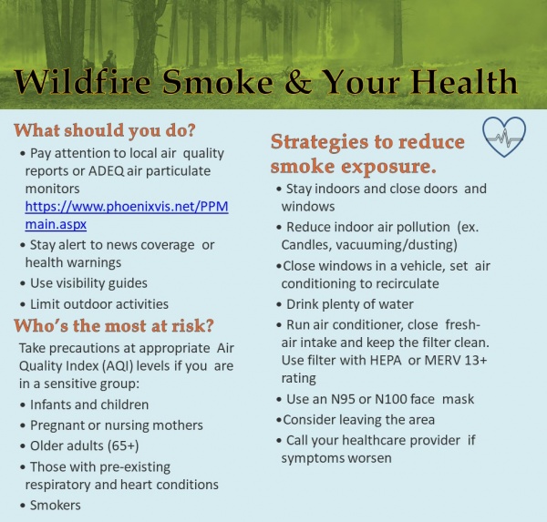
6/15/2020 – Several fires around the state have smoke coming toward our region due to the prevailing winds. Officials urge everyone to take the proper precautions to care for your health. Please see the information below for more ways to protect yourself and those you love from the impacts of wildfire smoke. Don’t forget to share this with family, friends and neighbors that may have health concerns.
**Note: Currently there are no new fires in Navajo or Apache Counties!

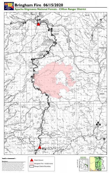
Jurisdiction: Apache-Sitgreaves National Forests, Clifton Ranger District
Resources: 4 hotshot crews, 2 initial attack crews, 2 Type 6 engines, 6 water tenders, 1 Type 1 helicopter, 1 Type 2 helicopter, 1 Type 3 helicopter, miscellaneous overhead
Start Date: June 6, 2020
Percent Containment: 5%
Origin Location: 22 miles north of Morenci, AZ
Cause: Lightning
Personnel: 304
Increased humidity and cooler temperatures carried in by surrounding thunderstorms helped to limit fire spread yesterday. Firefighters will continue to stay alert for increased thunderstorm activity, including any new lightning-caused fire starts, as the chance of precipitation grows to 25% today. Incident meteorologists indicate that a series of storms may move over the fire area today, bringing conflicting winds that could push the fire in multiple directions. Critical fire weather is possible later in the week as weather patterns shift to bring higher temperatures and drier conditions.
With the cooler temperatures moderating fire behavior, firefighters were able to begin assessing the risks to structures, including several cabins and ranch houses in area. A helicopter repel crew was flown into the Blue River corridor to begin structure protection efforts and create defensible space around the cabins. Future protection measures may include using aluminum structure wrap to protect the buildings from radiant heat and embers, if the fire were to move further in their direction.
The fire remains most active in the area around Red Mountain, burning through grasses and brush that make up the understory layer of timber forests. Firefighters are scouting for natural features such as ridgelines, trails and areas with exposed rock and sparse vegetation that could serve as holding lines. As crews monitor fire activity along Highway 191 and the area around Rose Peak, helicopters may assist ground crews by dropping water buckets to cool the fire’s edge. Crews continue to make progress along the highway, extinguishing any fires that threaten to cross over to the western side.
For the protection of the public and our firefighters, Highway 191 is closed in both directions between Mile Marker 189 (just past Juan Miller Road) and Mile Marker 225 (Blue Vista). This closure will remain in place through June 21, 2020 and may be extended as firefighters continue to secure the road corridor. Motorists should adjust travel plans accordingly. More information can be found at https://azdot.gov/adot-news/us-191-closed-eastern-arizona-mountains-due-bringham-fire.
Fire Information Officers are available from 8:00AM to 8:00PM to respond to questions via phone at (928) 288-2154 or email at 2020.bringham@firenet.gov. Additional fire information can be found at the following links:
• InciWeb: https://inciweb.nwcg.gov/incident/6747/
• Facebook (updates and daily operational videos): https://www.facebook.com/apachesitgreavesnfs/
• Interactive Bringham Fire Map: http://www.fs.usda.gov/goto/BringhamFireWebMap
• Temporary Closure Order: https://www.fs.usda.gov/detail/asnf/alerts-notices/?cid=stelprd3793918
Southwest Region Smoke Outlook: https://wildlandfiresmoke.net/outlooks/SouthwesternRegion