G22 Fire Update 4.10.2021

WHITE MOUNTAIN ZONE
Incident Management Team
Ben Plumb – Incident Commander
Public Information Officer: 928-245-1585

Firefighters Work To Corral G22 As Drying Trend Persists
G22 Fire Update: Saturday, April 10, 2021

Location of Origin: 10 miles northwest of Cibecue, Arizona
Start Date: April 4, 2021
Size: 1,611 Acres
Cause: Under Investigation
Percent Contained: 0
Personnel: 112
Fuels: Grass/brush understory, snags, pine-stringers
Resources Assigned: 4 Type 6 engines, 1 Type 4 engine, 2 dozers, 20 person IHC crew, 19-person IA hand crew, 10 person IA hand crew, 2 water tenders, medical team, 1 type 3 helicopter, and other miscellaneous incident management overhead.

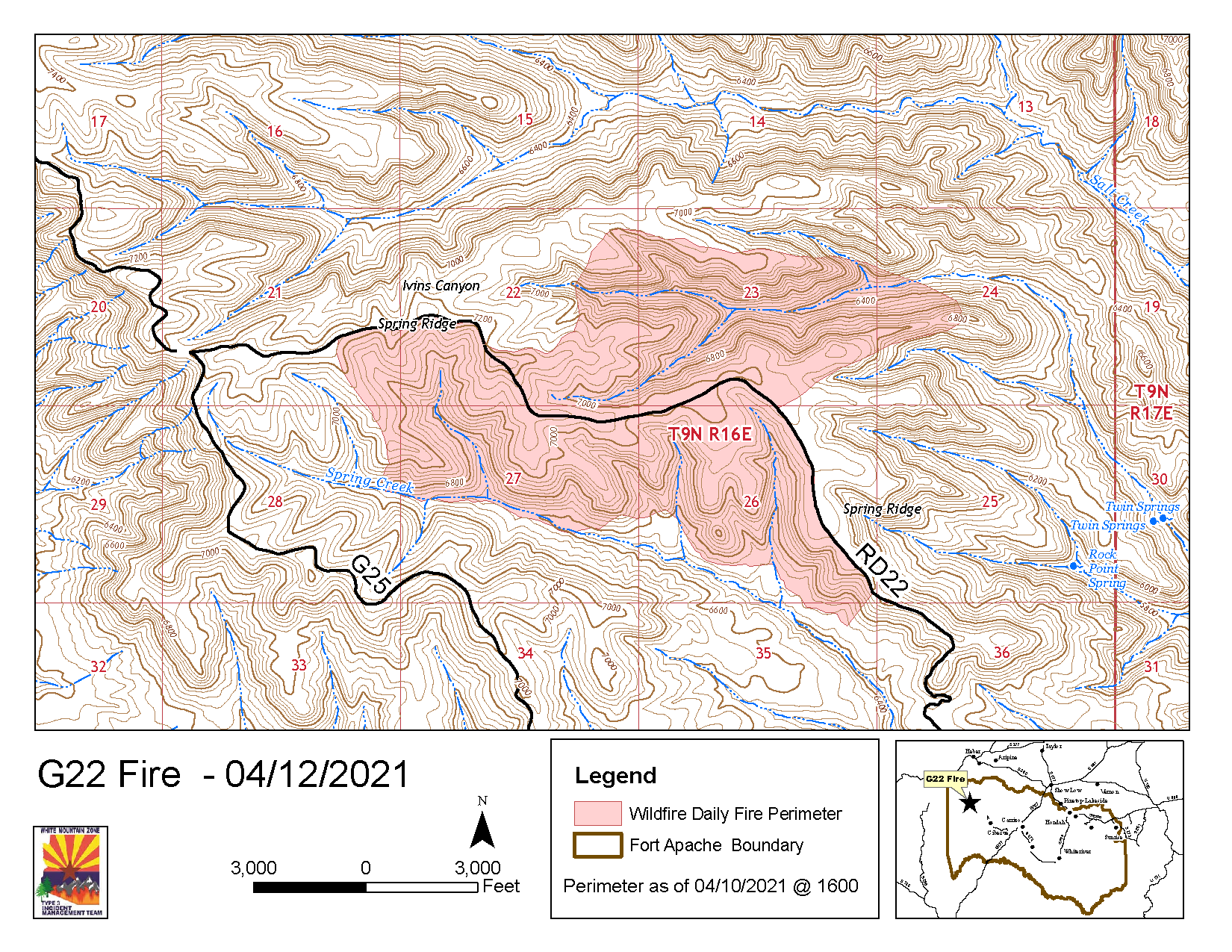
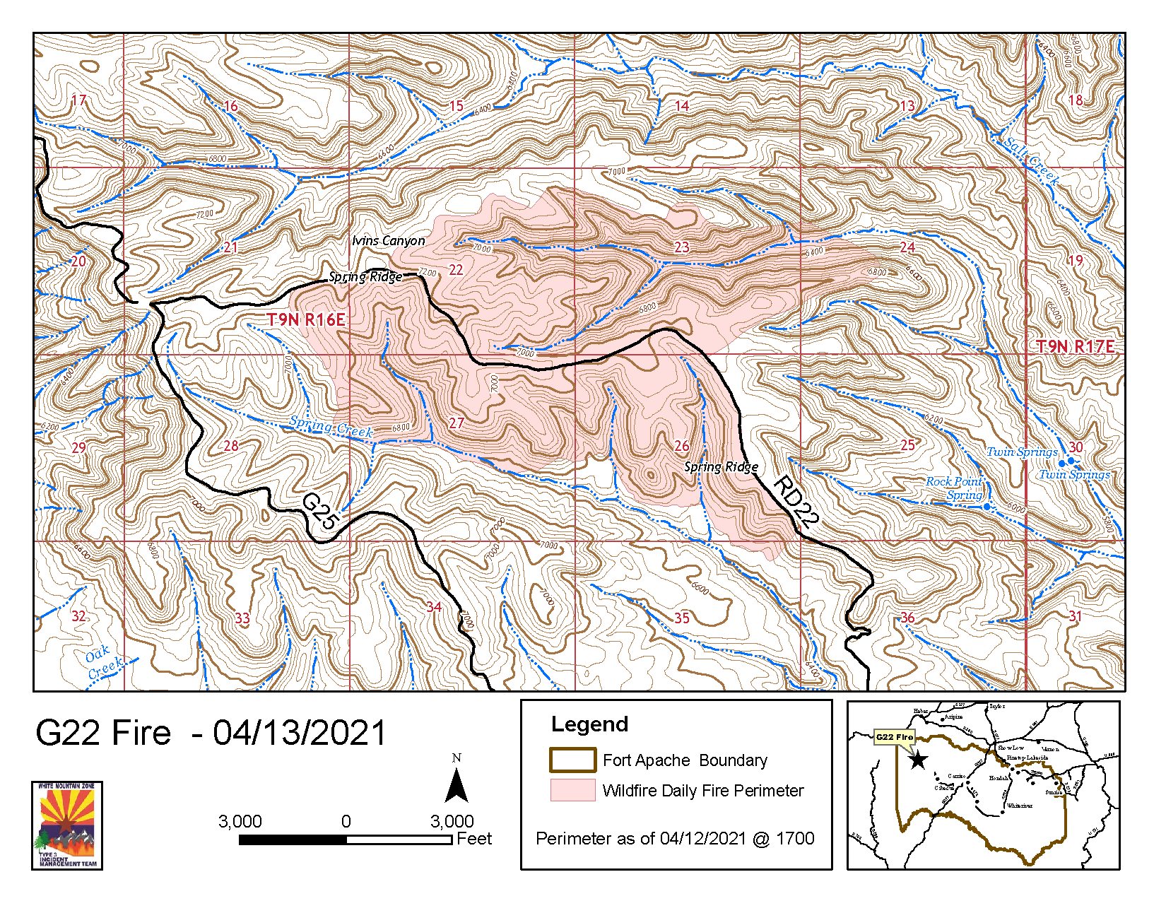
Operations: A favorable shift in wind direction slowed the G22 fires progression along the most active portions of the northern flanks yesterday. A few spot fires were identified and quickly contained. Firefighters monitored prior burnout operations and continued to prep the G32 and Springs Ridge roads to mitigate spread. Today, firefighters will monitor fire activity from yesterday’s operations, and continue to utilize dozer and handlines to contain the fire along the north and eastern flanks, while holding the already burned edges on the south and west portions of the fire.

Closures: The junction of the 27/28 road, north of Grasshopper Ranch and Salt Creek north of Chediski Lookout, is closed due to fire activity.

Weather: The drying trend is expected to continue today with slightly warmer temperatures near 75 degrees, and wind gusts up to 25 mph in the afternoon.

Values at risk: Fire fighter and public safety are the highest priorities for the incident management team. The G22 fire area includes important lands to the White Mountain Apache people. Firefighters are working to protect commercial timberlands, watersheds, riparian areas, rangelands, heritage sites, and recreation and wilderness areas.

Safety: Smoke may be visible from Cibecue and White Mountain communities, and along U.S. 60 and 260. Smoke-sensitive individuals and people with respiratory or heart disease are encouraged to take precautionary measures.

Official fire information can be found on these sites.
•G22 Fire Inciweb: https://inciweb.nwcg.gov/incident/7371/
•Facebook: https://www.facebook.com/BIAFAAFireMgt/
•Apache-Sitgreaves NFs: https://www.fs.usda.gov/news/asnf/news-events
•ADEQ Air Quality Information: https://azdeq.gov/node/7077

Lakeside East Broadcast Burn Area Prescribed Fire 2021

Lakeside, AZ, April 8, 2021— The Lakeside Ranger District will be conducting a 3,418 acre prescribed burn within the Lakeside East Broadcast burn area, south of Vernon beginning April 11, 2021 and continuing thru April 18, 2021, weather dependent.

The units located within the Lakeside East Broadcast burn area are:
Los Burros Unit – 1,744 acres
Pierce Mountain Unit – 912 acres
Reservation Tank Unit – 671 acres.

These units are located about eight miles south of Vernon, along Apache County Road 3140. The burn units are surrounded by Forest Service Roads 96, FSR 9G, FSR 9835 and Apache County Road 3140.

Ignition may last more than one day, with daily smoke impact anticipated within area drainages. Smoke will be visible in the local area, from Arizona State Highway 260, and U.S. Highway 60, in Springerville, Eager, Vernon, McNary, Pinetop-Lakeside and Show Low. In the interest of safety, forest visitors are reminded to obey all traffic signs and use caution when traveling in the vicinity of the prescribed fire burn units as firefighters and fire-related traffic may be in the area.

Prescribed burning provides many benefits and is essential for maintaining healthy forest ecosystems. This area has received some forest thinning within the past three to eight years, this burn continues the needed restoration treatment, providing habitat diversity, recycling plant nutrients into the soil, and encouraging new growth for a variety of plants used by wildlife and livestock. Prescribed burning of forest ground fuels also reduces the negative threat of large-scale wildfire impacts. This prescribed burn is in cooperation with the White Mountain Apache Tribe.

Crews will be on scene from ignition until there is no longer a threat of escape from the project boundaries. Questions or concerns contact the Lakeside Ranger District at 928-368-2100 or visit the ASNFs website at: www.fs.usda.gov/asnf

G22 Fire Update 4.7.21

The White Mountain Zone Type 3 Team has been ordered for the Incident and will assume command of the G22 Fire, at 6:00 a.m. tomorrow morning, April 8 2021.

Fire Activity and Operations: Yesterday, the fire cross one of the contingency lines within the northeast flank of the fire. Fire personnel conducted burnout operations along the 22H road to the G22 junction to keep the fire in check. There was minimal movement on the south flank of the fire.

Today, fire personnel will build indirect/direct handline in the southeast flank of the fire working along Spring Creek to the 32C junction. The roads within and surrounding the fire will continued to be cleared for access.

Road Closures: The junction of the 27/28 road, north of Grasshopper Ranch and Salt Creek north of Chediski Lookout is closed due to fire activity.

Values and Objectives: Firefighter and public safety is the number one priority for the G22 Fire. All fire actions will be assessed in relation to protecting values and minimizing impacts on cultural resources, wildlife, rangeland, watersheds, and natural resources.

If you have any questions regarding the fire, you can call Candy Lupe, Public Information Officer at (928) 205-5662 or you can log onto BIA Fort Apache Agency’s Facebook page, https://www.facebook.com/BIAFAAFireMgt.