
Springerville, AZ, May 4, 2023 — The Apache-Sitgreaves National Forests plan to conduct multiple prescribed fire operations beginning May 3 and continuing through May 20, 2023. The following prescribed fires will be initiated if conditions and approvals allow:
Lakeside Ranger District:
- Lakeside East-Antelope Unit Rx – May 8 through May 20. Location: Four miles to the southwest of Vernon, AZ. The project boundary is along and within County Road 3140, Forest Road three and four. The public should expect to see smoke from Hwy 60 and possibly 260 and will diminish each day after ignition. Total acres: 1,008 acres.
Springerville Ranger District:
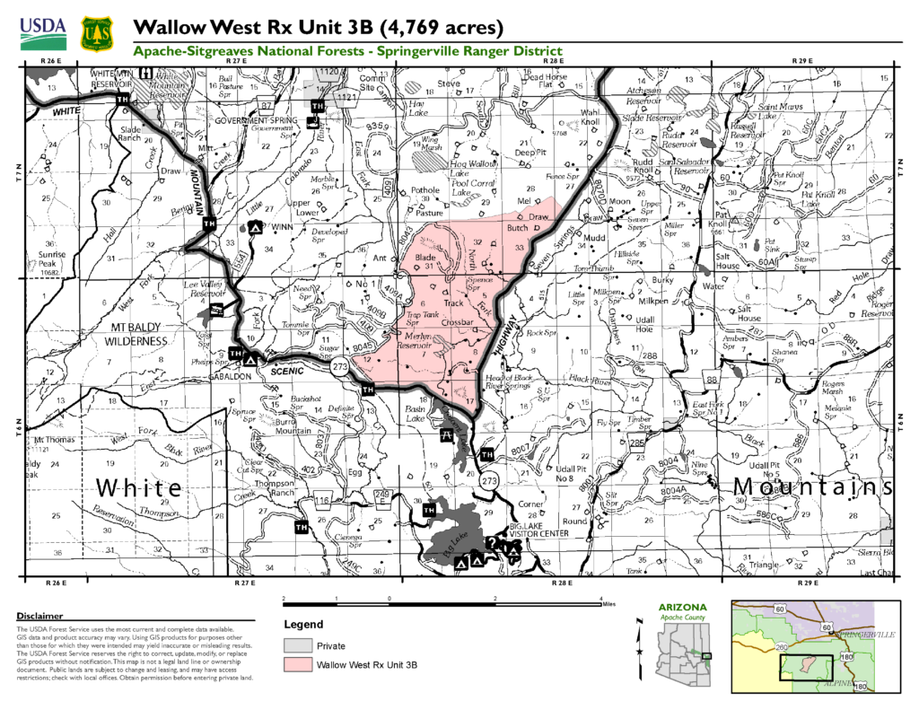
- Wallow West 3B Rx – May 8 through May 12. Location: The project area is located between Big Lake and Springerville adjacent to AZ State Highway 261. The unit is surrounded by a significant road system on all four sides consisting of dirt and graveled/paved roads. The unit is bound by Forest Road 409 on the west side, AZ State Highway 261 on the east side, AZ State highway 273 on the south and a two-track, dirt road, Forest Service Road 8403 on the north side. All roads are main routes of travel for many motorists visiting the Springerville Ranger District. All roads listed will serve as sufficient barriers to fire spread. Smoke will be visible from Greer, Springerville, Eager and possibly Nutrioso and Alpine. It may impact portions of AZ State Hwy 261, AZ State Hwy 273 and Forest Service Road 249 during implementation and possibly for a few days. Total acres 4,769.
- Wallow West 6 A Rx – May 8 through May 12. Location: The project area is bound by a significant road system along three sides. The West Fork of the Black River is a major perennial drainage and will constitute the western boundary. To the north, the boundary will be Forest Service Road 116 and Forest Service Road 249E which continues to the east and forms the eastern boundary of the unit. To the south, Forest Service Road 68C will be the southern boundary. Steepest slopes lie along the West Fork of the Black River Drainage. These areas that were once wet mixed conifer have been converted to open areas of grass with a heavy dead and down component. Bare ground and rock screes also cover much of the steeper slopes. The same is true of the NW corner of the unit. This area of wet mixed conifer is now open canopy grassland. Smoke will be visible from Greer, Springerville, Eager and possibly Nutrioso and Alpine. It may impact portions of AZ State Hwy 261, AZ State Hwy 273 and Forest Service Road 249 during implementation and possibly for a few days. Total acres 2,434.
Stay up to date on news from the A-S at our website https://www.fs.usda.gov/asnf, on Twitter @A_SNFs and on facebook.com/apachesitgreavesnfs.
###