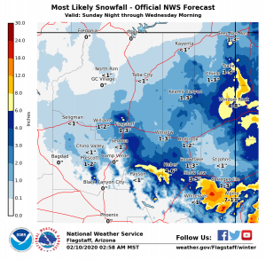
A storm system will move across the region today will exit the state by early Wednesday morning.
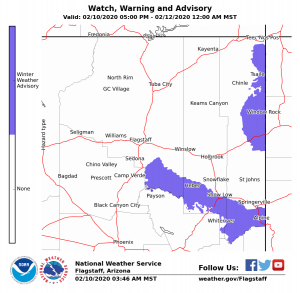
Accumulating snow is expected at higher elevations, with the most significant accumulations currently forecast in the White Mountains and along the Mogollon Rim east of Flagstaff where a Winter Weather Advisory has been issued from 5 PM Monday to Midnight Tuesday night.
A Winter Weather Advisoryhas been issued for Window Rock, Ganado, and areas near the Chuska Mountains from 5 PM Monday to midnight Tuesday Night.
Forecast confidence remains low to moderate at this time – snow amounts and timing could still change so please continue to watch for updates.