Cow Canyon Fire September 8, 2020
Location of Origin: Apache-Sitgreaves National Forests, Alpine Ranger District
Start Date: August 18, 2020 Size: Approx. 248 Acres
Cause: Lightning Percent Contained: 10
Personnel: 0
Resources Assigned: 0
The Cow Canyon Fire, ignited by lightning on August 18, 2020 on the Alpine Ranger District, Apache-Sitgreaves National Forests, is burning in steep, rugged terrain, is in a remote location within the Blue Range Primitive Area and has minimal values at risk, therefore, is in Monitor Status.
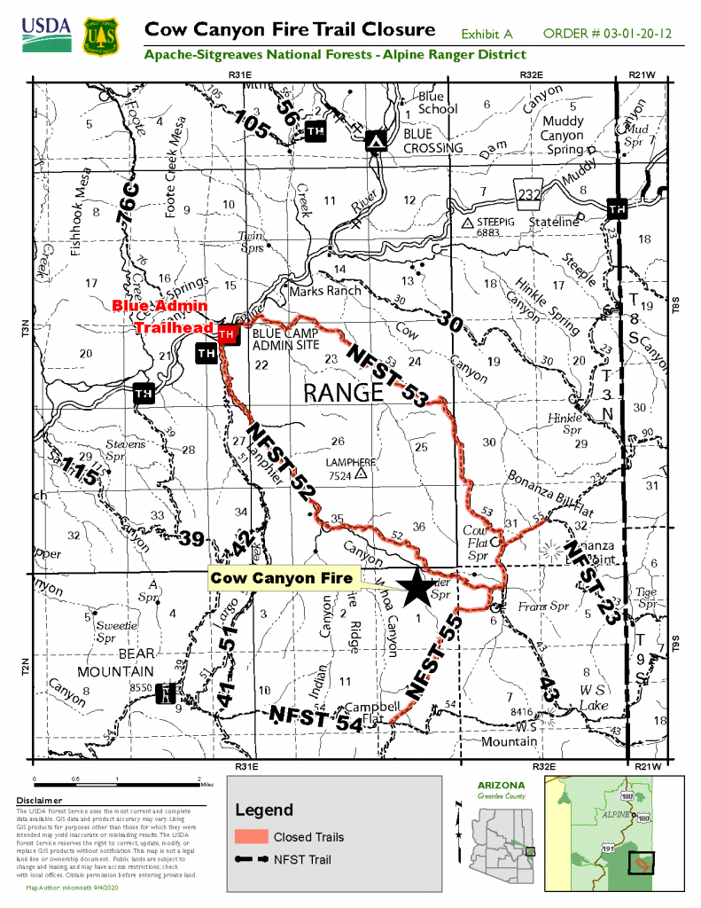
The Cow Canyon Fire, approximately four miles southeast of the Blue Camp in the Blue River Drainage, has grown to approximately 248 acres. The fire started on the north side of Lanphier Canyon and moved to the south crossing the canyon just to the west of Cashier Spring.
Franz Cabin and Corral are located to the east of the fire near Franz Spring. The fire will be monitored for movement to the east that may impact the cabin. Firefighters created a helispot near the cabin during the Whoa Canyon Fire in early July and will utilize that, if necessary, to help protect the cabin and corrals.
The Apache-Sitgreaves National Forests issued a temporary trail closure order effective today, September 8, 2020. The following trails are closed for public health and safety due to wildland fire activities along the trails:
Cow Flat Trail (#55) beginning at the trail junction of Bonanza Bill Trail (#23), following the Cow Flat Trail (#55) to the southwest until it meets the junction of WS Lake Trail (#54).
Lanphier Trail (#52) at the trailhead at the junction of National Forest Service Road (NFSR) 281, following the trail to the southeast until it meets Cow Flat Trail (#55).
South Canyon Trail (#53) at the trailhead at its junction with NFSR 281, following the trail to the southeast until it meets Cow Flat Trail (#55).
Smoke may be visible east of Hwy. 191 on the Alpine and Clifton Ranger Districts, west of Saddle Mountain, and near the town of Glenwood, New Mexico. Smoke-sensitive individuals and people with respiratory or heart disease are encouraged to take precautionary measures. Information on air quality and active prescribed burns can be found on Arizona Department of Environmental Quality’s webpage: https://azdeq.gov/.
For further information, please contact the Alpine Ranger District at 928-339-5000 or email Apache-Sitgreaves National Forests at as_portal_comments@usda.gov.
